Pannagam thodu
The Pannagam thodu, about 30 kilometer long which start from 14th mile of KK road region and flows through Madapattu, Mattakkara, Arumanoor, Ayarkunnam regions and joins the Meenachil near Punnathara, Kidangoor. The name Pannagam means snake, as the river’s route of flow is look like a snake curled because it surrounding many hills.
The pannagam thodu is formed by several streams originating from the small hills in the Pampady, Pallickathode, Kooropada Panchayat and rich with water during the flow through Akalakunnam, Arumanoor and Ayarkunnam Panchayat.
Environmental issues
The Pannagam thodu is almost free from water pollution. There are a few issues affecting the water pollution mainly by disposal of urban and domestic waste into the streams.
Economic importance of Pannagam thodu
Thousands of farmers use water from the river for agriculture. During monsoon the pannagam can be full or flooding. Illegal sand mining is rare in this stream. There is now acute shortage of water in summer.
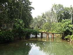
Bridges and check dams
The main Bridges are made at: Eruthupusza, Myladiyil kadav, Kaniparambu Mattakkara & Kongandoor (Charathupadi).
The main Check Dams are:
- Moongakuzhy check dam for Lakkatoor drinking water project.
- Kaniparambu check dam for Moozhoor drinking water project.