Panj River
| Panj River | |
|---|---|
 The Panj river forms much of the border between Tajikistan and Afghanistan | |
| Country | Afghanistan, Tajikistan |
| Physical characteristics | |
| Main source | confluence of Pamir and Wakhan Rivers |
| River mouth | Amu Darya |
| Length | 921 km (572 mi) |
| Discharge |
|
| Basin features | |
| Basin size | 114,000 km2 (44,016 sq mi) |
| Official name | Lower part of Pyandj River |
| Designated | 18 July 2001 |
| Reference no. | 1084[1] |
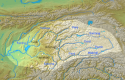
The Panj River (Pashto: د پنج سیند) (/ˈpɑːndʒ/; Tajik: Панҷ, پنج), also known as Pyandzh River or Pyanj River (derived from its Russian name "Пяндж"), is a tributary of the Amu Darya. The river is 1,125 km long and forms a considerable part of the Afghanistan–Tajikistan border.[2]
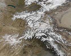
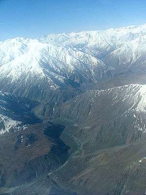
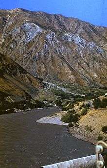
The river is formed by the confluence of the Pamir River and the Wakhan River near the village of Qila-e Panja. From there, it flows westwards, forming the border of Afghanistan and Tajikistan. After passing the city of Khorog, capital of the Gorno-Badakhshan Autonomous Region of Tajikistan it receives water from one of its main tributaries, the Bartang River. It then turns towards the southwest, before joining the river Vakhsh and forming the greatest river of Central Asia, the Amudarya. Panj played a very important role during Soviet times, and was a strategic river during the Soviet military operations in Afghanistan in the 1980s.
Water consumption
A water treaty between the Soviet Union and Afghanistan, signed in 1946, allows Afghanistan to draw 9 million cubic metres of water a year.[2] It currently draws 2 million cubic metres of water. According to the Panj River Basin Project environmental damage could be expected if Afghanistan drew the entire amount of water from the river that the treaty allows.
Bridges
- Afghanistan-Tajikistan Bridge: A highway bridge was built over the river between Tajikistan and Afghanistan at Nizhnii Panj. The contract was awarded in May 2005 and the construction of the bridge began in Jan 2006 and was completed in August 2007. The financing was provided by the USA, amounting to 37 million USD, and the construction was done by an Italian General Construction company Rizzani de Eccher S.p.A. under the ownership of US Army Corps of Engineers. The bridge replaces a barge that could transport only 60 cars a day and which was unusable many months in the year due to strong currents in the river. RAWA reports[3] that this facilitates the heroin trade, the key to the economic miracle in Afghanistan.
- Another bridge was built at the confluence with the Gunt River at Khorog in 2003.
- A bridge exists at Langar, which may still be closed.
The Aga Khan Development Network has been engaged in a project to build a series of three bridges across the Panj River between Tajikistan and Afghanistan.[4]
- The first of these bridges, connecting Tem on the Tajik side with Demogan on the Afghan side, was inaugurated by Tajikistan’s President Emomali Rahmonov, Afghanistan’s Vice-President Hedayat Amin Arsala and His Highness the Aga Khan in November, 2002.[4][5]
- This was followed by the inauguration of the Tajik-Afghan Friendship Bridge at Darwaz in July, 2004,[6]
- The Ishkashim bridge between Ishkashim, Afghanistan and Ishkashim, Tajikistan was inaugurated in October, 2006.[7][8]
References
- ↑ "Lower part of Pyandj River". Ramsar Sites Information Service. Retrieved 25 April 2018.
- 1 2 "Pyanj River Basin Project". Asian Development Bank. Archived from the original on February 19, 2011. Retrieved 2008-12-07.
- ↑ RAWA: U.S. built bridge is windfall for Afghan drug trade
- 1 2 "Darwaz Bridge to strengthen commercial ties and Tajik-Afghan relations". Aga Khan Development Network. Archived from the original on 2008-12-04. Retrieved 2008-12-04.
- ↑ "Press Release: Aga Khan and Tajik and Afghan Leaders Open Bridge into Afghanistan". Aga Khan Development Network. 2002-11-03. Retrieved 2006-12-09.
- ↑ "Press Release: Darwaz Bridge to strengthen commercial ties and Tajik-Afghan relations - AKDN,". Aga Khan Development Network. 2004-07-06. Archived from the original on 2006-12-06. Retrieved 2006-12-09.
- ↑ "Remarks by the Aga Khan at the Inauguration of the Ishkashim Bridge - AKDN, October 31, 2006". Aga Khan Development Network. 2006-10-31. Retrieved 2006-12-09.
- ↑ "News: Aga Khan and President Rahmonov inaugurate reconstructed bridge in Ishkashim". Asia-Plus. 2006-10-31. Archived from the original on 2007-09-27. Retrieved 2006-12-10.
See also
Coordinates: 37°06′39″N 68°18′53″E / 37.11083°N 68.31472°E