Palizada Municipality
| Palizada | ||
|---|---|---|
| Municipality | ||
| ||
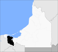 Location of Palizada in Campeche | ||
|
Palizada Location of Palizada in Campeche | ||
| Coordinates: 18.25°0′N 92.1°0′W / 18.250°N 92.100°WCoordinates: 18.25°0′N 92.1°0′W / 18.250°N 92.100°W | ||
| Country |
| |
| State | Campeche | |
| Municipal seat | Palizada | |
| Government | ||
| • Municipal president | (2006-09) | |
| Area | ||
| • Total | 2,143.28 km2 (827.53 sq mi) | |
| Population (2015) | ||
| • Total | 8,971 | |
| • Density | 4.2/km2 (11/sq mi) | |
| Time zone | UTC-6 (CST) | |
| • Summer (DST) | UTC-5 (CDT) | |
| Created | 1 January 1916 | |
| Website | www.palizada.gob.mx/ | |

Palizada (Spanish ![]()
History and geography
The municipality of Palizada borders to the west with the state of Tabasco and to the east with the neighbouring Campeche municipality of Carmen. It covers a total surface area of 2,071.70km².
Demographics
As of 2010, the municipality had a total population of 8,352.[1]
As of 2010, the town of Palizada had a population of 3,089.[1] Other than the town of Palizada, the municipality had 256 localities, none of which had a population over 1,000.[1]
References
- 1 2 3 4 "Palizada". Catálogo de Localidades. Secretaría de Desarrollo Social (SEDESOL). Retrieved 23 April 2014.
- Link to tables of population data from Census of 2005 INEGI: Instituto Nacional de Estadística, Geografía e Informática
- Palizada Enciclopedia de los Municipios de México
External links
- Ayuntamiento de Palizada Official website (in Spanish)
- Municipio de Palizada from official Campeche state government website (in Spanish)
Campeche (capital) | ||
| Municipalities and (municipal seats) |  | |
This article is issued from
Wikipedia.
The text is licensed under Creative Commons - Attribution - Sharealike.
Additional terms may apply for the media files.