Pak Sha Chau (Sai Kung)
| Native name: 鴨洲 | |
|---|---|
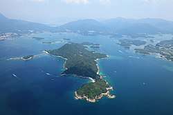 Pak Sha Chau is the small island with tombolo located to the Northwest of Kiu Tsui Chau (Sharp Island) the biggest island centered in the photo. | |
| Geography | |
| Administration | |
| Districts | Sai Kung District |
Pak Sha Chau (Chinese: 白沙洲; pinyin: Báishā Zhōu; literally: "White Sand Island") is an island of Hong Kong. Administratively, it is part of the Sai Kung District and Kiu Tsui Country Park located to the northwest of Kiu Tsui Chau.
See also
| Wikimedia Commons has media related to Pak Sha Chau (Sai Kung). |
Coordinates: 22°22′28″N 114°17′08″E / 22.37456°N 114.285612°E
This article is issued from
Wikipedia.
The text is licensed under Creative Commons - Attribution - Sharealike.
Additional terms may apply for the media files.