Ozeros
| Ozeros | |
|---|---|
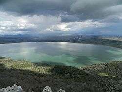 View of Ozeros lake | |
| Location | Aetolia-Acarnania |
| Coordinates | 38°39′21″N 21°13′27″E / 38.65583°N 21.22417°ECoordinates: 38°39′21″N 21°13′27″E / 38.65583°N 21.22417°E |
| Type | natural |
| Basin countries | Greece |
| Max. length | 5 km (3.1 mi) |
| Max. width | 3 km (1.9 mi) |
| Surface area | 10 km2 (3.9 sq mi) |
| Max. depth | 10 m (33 ft) |
| Settlements | Agios Konstantinos |
Lake Ozeros (Greek: Οζερός, Λίμνη Οζερού) is a lake located west of Agrinio. The lake is formed from the waters of the Acheloos river, flowing from the northwest. The lake has a surface of ca. 10 km2 and an average depth of 8–10 m, but this varies greatly with the season. The GR-5/E55 (Antirrio - Agrinio - Ioannina) runs to the northeastern side.
Nearest places
This article is issued from
Wikipedia.
The text is licensed under Creative Commons - Attribution - Sharealike.
Additional terms may apply for the media files.