Ougeotte
| Ougeotte | |
| River | |
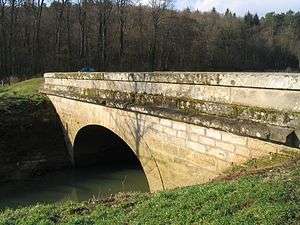 The "pont aux oies" (goose bridge) at Montigny-lès-Cherlieu | |
| Country | France |
|---|---|
| Region | Franche-Comté |
| Department | Haute-Saône |
| Source | |
| - location | Ouge |
| - coordinates | 47°46′38″N 5°41′13″E / 47.7773°N 5.687°E |
| Mouth | Saône |
| - location | Gevigney-et-Mercey |
| - coordinates | 47°49′00″N 5°58′11″E / 47.8168°N 5.9696°ECoordinates: 47°49′00″N 5°58′11″E / 47.8168°N 5.9696°E |
| Length | 27.3 km (17 mi) |
| Area | 100 km2 (39 sq mi) |
| Discharge | |
| - average | 1 m3/s (35 cu ft/s) |
The Ougeotte is a 27.3 km river in the department of Haute-Saône in the region of Franche-Comté in the eastern France. It is a sub-tributary of the Rhône via the Saône.
Geography
The Ougeotte rises in Ouge, which gives its name to the river. It flows generally east, receiving the Gailley at Chauvirey-le-Vieil, then the Écrevisses stream on the right of the ancient Agneaucourt mill, then joining the Saône at Gevigney-et-Mercey near Montureux-lès-Baulay.
Nowadays there are no more mills which take power from the Ougeotte, while at the beginning of the 19th century there were many:
- Ouge: le Moulinot
- Chauvirey: le Bouvot, le Maublanc, la Guerelle, le Grand Moulin
- Montigny-lès-Cherlieu: Montigny, Agneaucourt, and on the tributary stream: le Ferry and le Battant
- Noroy
- Bougey: la Perrière
- Gevigney: Vachez, le Moulin Neuf
- Montureux-lès-Baulay
In the 1840s, the Ougeotte was populated by burbot, pike, eel and perch. By 1960, it was fished for trout and crayfish.
Notes and references
This article is issued from
Wikipedia.
The text is licensed under Creative Commons - Attribution - Sharealike.
Additional terms may apply for the media files.