Otjozondjupa Region
| Otjozondjupa Region | |
|---|---|
| Region | |
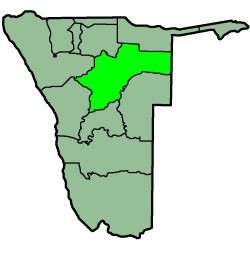 Location of the Otjozondjupa Region in Namibia | |
| Country | Namibia |
| Capital | Otjiwarongo |
| Government | |
| • Governor | Otto Ipinge[1] |
| Area[2] | |
| • Total | 105,460 km2 (40,720 sq mi) |
| Population (2011)[2] | |
| • Total | 142,400 |
| • Density | 1.4/km2 (3.5/sq mi) |
| Time zone | UTC+2 (CAT) |
Otjozondjupa region is one of the fourteen regions of Namibia, its capital is Otjiwarongo. An outstanding landmark within this region is the Waterberg Plateau Park. Administration offices are based in Otjiwarongo which is the largest town in the region.
In the east, Otjozondjupa borders the North-West District of Botswana. Domestically, it borders the following regions:
- Omaheke - southeast
- Khomas - south
- Erongo - southwest
- Kunene - northwest
- Oshikoto - north
- Kavango - northeast
Otjozondjupa borders more regions than any other region of Namibia.
Politics
Governor of Otjozondjupa is Otto Ipinge.[1] The region comprises seven constituencies:
In the 2015 regional elections Swapo won five of the seven constituencies, and National Unity Democratic Organisation (NUDO) won two.[3][4]
Economy and infrastructure
Otjiwarongo, Grootfontein, Otavi, and Okahandja are linked by rail and by the main trunk road running from south to north. Communication systems between these areas are also of a high standard.
The farming activities of Okahandja and Otjiwarongo are homogenous as these parts are well known for cattle farming. The Otavi and Grootfontein districts, and to a lesser extent also Otjiwarongo, are the granary of Namibia. The region also has a great potential to establish industries connected with such farming activities and by-products of it. It further has the advantage of combining communal and commercial farming in the same region.
The infrastructure of the region is such that effective administration is possible. The state of development in the area, and the facilities available, form a solid basis for future development. This region has the potential to be economically independent.
According to the 2012 Namibia Labour Force Survey, unemployment in the region is 25.3%.[5] Otjozondjupa has 72 schools with a total of 36,284 pupils.[6]
See also
References
- 1 2 "President announces governors". The Namibian. 10 April 2015.
- 1 2 "Namibia's Population by Region". Election Watch. Institute for Public Policy Research (1): 3. 2013.
- ↑ "Regional Council Election Results 2015". Electoral Commission of Namibia. 3 December 2015. pp. 20–21. Archived from the original on 8 December 2015.
- ↑ Menges, Werner (29 November 2015). "Mixed results for opposition in regional polls". The Namibian.
- ↑ Duddy, Jo Maré (11 April 2013). "Unemployment rate still alarmingly high". The Namibian. Archived from the original on 14 April 2013.
- ↑ Miyanicwe, Clemans; Kahiurika, Ndanki (27 November 2013). "School counsellors overstretched". The Namibian. p. 1.
| Wikimedia Commons has media related to Otjozondjupa. |
Constituencies in the Otjozondjupa Region of Namibia | ||
|---|---|---|