Otira River
| Otira River | |
|---|---|
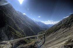 Upper Otiria River and Otiria Viaduct | |
| Country | New Zealand |
| Physical characteristics | |
| Main source | Mount Rolleston |
| River mouth | Taramakau River |
| Length | 20 km (12 mi) |
The Otira River is located in the central South Island of New Zealand. It rises on the slopes of Mount Rolleston in the Southern Alps, and flows north for 20 km, passing through the town of Otira before joining the Taramakau River. The Taramakau's outflow is into the Tasman Sea, 12 km south of Greymouth.
The valley of the Otira River forms the northwestern approach to Arthur's Pass, one of the three main passes across the Southern Alps.
Coordinates: 42°45′S 171°38′E / 42.750°S 171.633°E
This article is issued from
Wikipedia.
The text is licensed under Creative Commons - Attribution - Sharealike.
Additional terms may apply for the media files.