Ortigueira
| Ortigueira | |||
|---|---|---|---|
| City council | |||
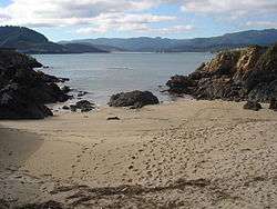 Orbeiro Beach. | |||
| |||
 Ortigueira Location in Spain. | |||
| Coordinates: 43°40′59″N 7°51′00″W / 43.68306°N 7.85000°W | |||
| Country | Spain | ||
| Autonomous community | Galicia | ||
| Province | A Coruña | ||
| Comarca | Ortegal | ||
| Government | |||
| • Mayor | Rafael Girón | ||
| Area | |||
| • Total | 209.60 km2 (80.93 sq mi) | ||
| Population (2009) | |||
| • Total | 7,150 | ||
| • Density | 34/km2 (88/sq mi) | ||
| Demonym(s) | Orteganos | ||
| Time zone | UTC+1 (CET) | ||
| • Summer (DST) | UTC+2 (CEST) | ||
| Website | Official website | ||
Ortigueira is a seaport and municipality in the province of A Coruña the autonomous community of Galicia in northwestern Spain. It belongs to the comarca of Ortegal. It is located on the northern slope of the Serra da Faladoira, the river Mera and on the eastern shore of the Ria de Santa Marta—a winding, rock-bound and much indented inlet of the Bay of Biscay, between Capes Ortegal and Bares, the northernmost headlands of the Peninsula. The town is noted for its romantic surroundings and sea bathing opportunities.
Port of Espasante (Ortigueira)
The industries are fishing and farming. The harbour is well sheltered. Owing to its shallowness, large vessels cannot enter, but there is an important coasting trade, despite the dangerous character of the coast and the prevalence of fogs and gales.
Sources


City Councils of the three Regions of Ferrolterra | ||
|---|---|---|
| Ferrol |  | |
| Eume | ||
| Ortegal | ||
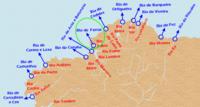
Ports and lighthouses under the Authority of Ferrol-San Cibrao | ||
|---|---|---|
|  | |
| Authority control |
|---|