Oregon Route 46
| ||||
|---|---|---|---|---|
 | ||||
| Route information | ||||
| Maintained by ODOT | ||||
| Length | 19.33 mi[1] (31.11 km) | |||
| Existed | 1932 – present | |||
| Component highways | Oregon Caves Highway No. 38 | |||
| Major junctions | ||||
| West end |
| |||
| East end | Oregon Caves National Monument and Preserve | |||
| Highway system | ||||
| ||||

Oregon Route 46 is an Oregon state highway that runs between the city of Cave Junction and the Oregon Caves National Monument and Preserve. OR 46 traverses the Oregon Caves Highway No. 38 of the Oregon state highway system.[2]
Route description
OR 46 starts in Cave Junction, at an intersection with U.S. Route 199. It then heads east into the Siskiyou Mountains, terminating at a parking lot for the Oregon Caves National Monument and Preserve. A forest service road (Grayback Road, NF-4611) splits east from OR 46, eventually reaching the Rogue River Valley and Oregon Route 238.

US 199 and Oregon Caves Highway Intersection
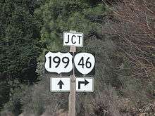
US 199 & Oregon 46 Sign
Major intersections
The entire route is in Josephine County. [1]
| Location[1] | mi[1] | km | Destinations | Notes | |
|---|---|---|---|---|---|
| Cave Junction | 0.00 | 0.00 | |||
| | 19.33 | 31.11 | Oregon Caves National Monument and Preserve Main Parking Lot | ||
| 1.000 mi = 1.609 km; 1.000 km = 0.621 mi | |||||
References
- 1 2 3 4 Road Inventory and Classification Services Unit. "Straightline Charts". Transportation Development Division, Oregon Department of Transportation. Retrieved September 28, 2016.
- Oregon Caves Highway No. 38 (September 2015)
- ↑ Road Inventory and Classification Services Unit. "2012 Cross Reference Table of Highway Route Number to State Highway Number" (PDF). Transportation Development Division, Oregon Department of Transportation. Retrieved September 28, 2016.
This article is issued from
Wikipedia.
The text is licensed under Creative Commons - Attribution - Sharealike.
Additional terms may apply for the media files.