Hazelton, British Columbia
| Hazelton | |
|---|---|
| Village | |
| The Corporation of the Village of Hazelton[1] | |
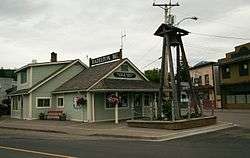 Village of Hazelton Municipal Office | |
 Location of Hazelton in British Columbia | |
| Coordinates: 55°15′36″N 127°38′44″W / 55.25990°N 127.64547°W | |
| Country |
|
| Province |
|
| Regional district | Kitimat-Stikine |
| Government[2] | |
| • Type | Municipal incorporation |
| • Mayor | Alice Maitland |
| Area[3] | |
| • Total | 2.80 km2 (1.08 sq mi) |
| Elevation | 305 m (1,001 ft) |
| Population (2011)[3] | |
| • Total | 270 |
| • Density | 96/km2 (250/sq mi) |
| Time zone | UTC−8 (PST) |
| • Summer (DST) | UTC−7 (PDT) |
| Website | Official website |
Hazelton is a village located at the junction of the Bulkley and Skeena Rivers in northern British Columbia, Canada. It was founded in 1866 and has a population of 305 (2011). The nearby larger community of New Hazelton is the northernmost point of the Yellowhead Highway, a major interprovincial highway which runs from Prince Rupert, British Columbia to Portage la Prairie, Manitoba.
The Hazelton area comprises two municipalities (the Village of Hazelton and District of New Hazelton), three unincorporated settlements (South Hazelton, Two Mile and the Kispiox Valley), four First Nations’ villages: three of which are of the Gitxsan people (Gitanmaax, Glen Vowell and Kispiox) and one of the Wet'suwet'en people - (Hagwilget).
First Nations history
The Hazeltons are home to the Gitxsan and Wet'suwet'en First Nations.
Old Hazelton and Two Mile
Hazelton is one of the oldest settlements in Northern British Columbia; its European settlement dates back to 1866 when the Collins Overland telegraph went through.[4]
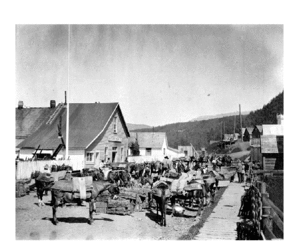
Hazelton was the original gateway and staging area for the Omineca Gold Rush of 1869-73. Besides the hunt for riches, there was one other important reason to visit: it had the only proper hospital for hundreds of miles in any direction. One of its other, less appreciated, distinctions was in having dozens of roaming, foraging and howling sled dogs, as nearly everyone had their own team and many were allowed to run free. Transportation options got better in 1891 when the Hudson's Bay Company’s sternwheeler Caledonia arrived from Port Essington. Being the head of navigation on the Skeena, Hazelton was to play host to more than a dozen sternwheelers throughout the next twenty-two years.
Two Mile was a community two miles out of Hazelton. During the gold rush and rail construction, it was home to a roadhouse and a prosperous red-light district.
New Hazelton and South Hazelton
When it was announced in 1903, that the Grand Trunk Pacific Railway would be coming through near Hazelton, another flurry of excitement erupted and hundreds of settlers poured into the district, buying whatever land they could get a hold of. Everyone was certain there was a fortune to be made and Hazelton was widely advertised as the "Spokane of Canada". What made Hazelton even more attractive was her mines, the Silver Standard and the Rocher de Boule. In 1911 two rival town-sites, Robert Kelly’s New Hazelton and the Grand Trunk Pacific’s South Hazelton both came into existence and competed to sell the most lots. Thus, the original Hazelton was called "Old" and together they became known as the "Three Hazeltons". Where the railway station would be built was an issue for many years until both South and New Hazelton received one.
The first car in Hazelton 1911
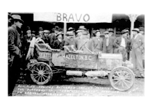
The first car, a Flanders 20, arrived in Hazelton on the evening of October 4, 1911. It came from Seattle. It did not arrive by rail, which wouldn't be completed from Prince Rupert until 1912, nor did it come in by sternwheeler. It was brought in overland from Seattle. None of the people in town believed that story, as it was nearly impossible to walk into Hazelton overland in 1911, much less drive. The next day everyone went to go see the car where it was parked in front of the Hazelton Hotel and questioned the owner, PE Sands, on how he had accomplished the feat. At a banquet held in his honor later that evening, Sands revealed his secret. He had brought along a mechanic and they had often had to disassemble the car and load it unto mules. Clearly they'd had enough of doing that by the time they reached Hazelton. They packed the car up on a sternwheeler and went to Skeena Crossing (Gitsegukla) where the car was loaded on the Grand Trunk Pacific Railway for the trip to Prince Rupert. There the car was loaded on a coastal steamer for the trip back to Seattle. At a banquet given in Seattle by the Pacific Highway Association in November, he was presented with the Challoner & Mitchell trophy, a solid 14 ct. gold medallion in the shape a small wheel, now owned by the Village of Hazelton. Note: This automobile is now on display at the Kittitas County Historical Museum in Ellensburg,WA.
The Union Bank robberies of 1913 and 1914

In November 1913, the Union Bank at New Hazelton was robbed by gunmen. In the commission of the crime, a young bank teller by the name of Jock McQueen was mortally wounded. Even though a posse was swiftly formed to go after them, the bandits got away with $16,000, a great deal of money in those days.

The second robbery occurred on April 7, 1914, already a red letter day for the area as the last spike of the Grand Trunk Pacific Railway was being driven 180 miles away in Fort Fraser. Little did anyone know that an equally historic event was about to happen right there in New Hazelton, one that would be remembered in hundreds of Canadian history books. Luckily, someone was there with a camera. Those pictures would become among the most famous of that era in British Columbia.
Climate
Hazelton has humid continental climate (Köppen climate classification Dfb).[5] Winters are cold but are milder than what the latitude may suggest, owing to pacific air masses. The average temperature in January is −8.9 °C (16.0 °F) and from December to February, there are an average of 32 days where the maximum temperature reaches or surpasses freezing.[6] However, arctic air masses can push temperatures below −30.0 °C (−22.0 °F), occurring on 3 days per year.[6] The average annual snowfall is 185 centimetres (72.8 in). Summers are warm with a July daytime high of 23.3 °C (73.9 °F) although nighttime temperatures are cool, with a July low of 9.1 °C (48.4 °F). In an average summer, there are 7 days where the temperature exceeds 30 °C (86.0 °F).[6] The average annual precipitation is 614 millimetres (24 in) with March and April being the driest months and October through January being the wetter months.[6] The record high was 36.7 °C (98.1 °F) on August 20, 1977 and the record low was −40.5 °C (−40.9 °F) on January 8, 1991.[6]
| Climate data for Hazelton | |||||||||||||
|---|---|---|---|---|---|---|---|---|---|---|---|---|---|
| Month | Jan | Feb | Mar | Apr | May | Jun | Jul | Aug | Sep | Oct | Nov | Dec | Year |
| Record high °C (°F) | 8.9 (48) |
11.0 (51.8) |
17.0 (62.6) |
26.7 (80.1) |
32.5 (90.5) |
34.5 (94.1) |
36.0 (96.8) |
36.7 (98.1) |
32.2 (90) |
21.5 (70.7) |
12.5 (54.5) |
8.0 (46.4) |
36.7 (98.1) |
| Average high °C (°F) | −5.4 (22.3) |
0.1 (32.2) |
6.7 (44.1) |
13.2 (55.8) |
17.5 (63.5) |
21.0 (69.8) |
23.3 (73.9) |
23.0 (73.4) |
17.2 (63) |
9.6 (49.3) |
0.6 (33.1) |
−4.2 (24.4) |
10.2 (50.4) |
| Daily mean °C (°F) | −8.9 (16) |
−4.5 (23.9) |
0.9 (33.6) |
6.2 (43.2) |
10.5 (50.9) |
13.8 (56.8) |
16.3 (61.3) |
15.9 (60.6) |
11.5 (52.7) |
5.5 (41.9) |
−2.2 (28) |
−7.1 (19.2) |
4.8 (40.6) |
| Average low °C (°F) | −12.3 (9.9) |
−9.2 (15.4) |
−4.9 (23.2) |
−0.8 (30.6) |
3.4 (38.1) |
6.7 (44.1) |
9.1 (48.4) |
8.7 (47.7) |
5.8 (42.4) |
1.3 (34.3) |
−5.1 (22.8) |
−10.0 (14) |
−0.6 (30.9) |
| Record low °C (°F) | −40.5 (−40.9) |
−35.0 (−31) |
−30.0 (−22) |
−11.1 (12) |
−5.0 (23) |
−1.1 (30) |
0.0 (32) |
−0.5 (31.1) |
−4.0 (24.8) |
−22.0 (−7.6) |
−32.5 (−26.5) |
−39.0 (−38.2) |
−40.5 (−40.9) |
| Average precipitation mm (inches) | 69.2 (2.724) |
37.2 (1.465) |
24.2 (0.953) |
27.2 (1.071) |
41.9 (1.65) |
52.6 (2.071) |
48.9 (1.925) |
49.0 (1.929) |
60.9 (2.398) |
74.7 (2.941) |
64.6 (2.543) |
63.7 (2.508) |
613.9 (24.169) |
| Average rainfall mm (inches) | 11.7 (0.461) |
13.4 (0.528) |
13.2 (0.52) |
24.9 (0.98) |
41.9 (1.65) |
52.6 (2.071) |
48.9 (1.925) |
49.0 (1.929) |
60.9 (2.398) |
71.9 (2.831) |
29.4 (1.157) |
11.5 (0.453) |
429.1 (16.894) |
| Average snowfall cm (inches) | 57.5 (22.64) |
23.8 (9.37) |
11.0 (4.33) |
2.3 (0.91) |
0 (0) |
0 (0) |
0 (0) |
0 (0) |
0 (0) |
2.8 (1.1) |
35.1 (13.82) |
52.2 (20.55) |
184.7 (72.72) |
| Average precipitation days (≥ 0.2 mm) | 14.9 | 11.1 | 9.8 | 11.2 | 14.2 | 14.1 | 13.5 | 13.4 | 16.1 | 18.2 | 16.0 | 14.5 | 167.0 |
| Average rainy days (≥ 0.2 mm) | 3.7 | 4.5 | 6.5 | 10.7 | 14.2 | 14.1 | 13.5 | 13.4 | 16.1 | 17.8 | 8.4 | 3.4 | 126.3 |
| Average snowy days (≥ 0.2 cm) | 12.3 | 7.7 | 4.4 | 0.75 | 0 | 0 | 0 | 0 | 0 | 0.92 | 9.5 | 12.7 | 48.2 |
| Source: Environment Canada[6] | |||||||||||||
Notable people
- Carol Huynh - 2008 Freestyle Wrestling Olympic gold medalist
- Cataline – a well-known packer. He served Hazelton throughout most of his career and also chose to retire in Hazelton.
- Dave Hancock - 15th premier of Alberta
- Simon Gunanoot – a merchant in the region
- Sperry Cline a Boer War veteran, policeman and author
Attractions
- 'Ksan Historical Village is a world-famous native heritage site located right where the Bulkley and Skeena rivers meet.
- Hagwilget Canyon Bridge is one of North America's highest suspension bridges.
- Steelhead Fishing can be done at the nearby Kispiox River.
Special events
- Kispiox Valley Rodeo is held the first weekend in June,
- Kispiox Valley Music Festival is held the last weekend of July.
- Pioneer Day takes place on the second Saturday of August.
- Gitxsan Cultural Days takes place on the third weekend in August.
Book references
- The Far Land, Eva MacLean ISBN 0-920576-41-9
- The Skeena River of Destiny, Dr. RG Large ISBN 1-895811-19-8
- Pioneer Legacy Chronicles of the Lower Skeena River, Norma Bennet ISBN 0-9683026-0-2
- A Thousand Blunders, the Grand Trunk Pacific Railway and Northern British Columbia, Frank Leonard ISBN 0-7748-0532-3
- Barner, A. Surgeon of the Skeena : a brief résumé of the life and work of Rev. Horace C. Wrinch, M.D., D.D., Hazelton, B.C. The Committee on Missionary Education, The Literature Dept., Woman’s Missionary Society : [and] the United Church of Canada, [194?]
- "The unmasking of Ksan", Eric Wilson ISBN 0-00-223182-4
Musical references
- "Hazelton", on Hazeltons by Justin Vernon
See also
- 1950 British Columbia B-36 crash, a crash near to Hazelton in 1950 of a nuclear-armed American bomber.
Notes
- ↑ "British Columbia Regional Districts, Municipalities, Corporate Name, Date of Incorporation and Postal Address" (XLS). British Columbia Ministry of Communities, Sport and Cultural Development. Retrieved November 2, 2014.
- ↑ Village of Hazelton. "Village council". Archived from the original on 2008-05-16. Retrieved 2008-06-16.
- 1 2 Statistics Canada (2006 Census). "Hazelton Community Profile". Retrieved 2008-06-16. Check date values in:
|year=(help) - ↑ OurBC.com. "Hazelton". Retrieved 2007-08-13.
- ↑ Kottek, M.; J. Grieser; C. Beck; B. Rudolf; F. Rubel (2006). "World Map of the Köppen-Geiger climate classification updated" (PDF). Meteorol. Z. 15 (3): 259–263. doi:10.1127/0941-2948/2006/0130. Retrieved December 22, 2012.
- 1 2 3 4 5 6 "Canadian Climate Normals 1971-2000". Environment Canada. Retrieved December 22, 2012.
External links
| Wikimedia Commons has media related to Hazelton, British Columbia. |
- Hazelton, British Columbia Homepage
- Village of Hazelton Homepage
- 'Ksan Native Village & Museum
- Kispiox Valley Music Festival
| Subdivisions |  | |
|---|---|---|
| Communities | ||
| Metro areas and agglomerations | ||
| Villages |
| |
| ||