Ob' Bay
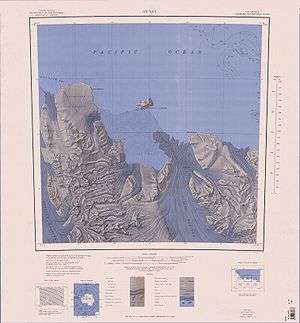
1:250,000 scale topographic map of the Ob' Bay area including Lillie Glacier
Ob' Bay is a bay lying between Lunik Point and Cape Williams. Lillie Glacier Tongue occupies the east part of the bay. The bay was charted by the Soviet Antarctic Expedition (1958) and named after the expedition ship Ob' .
Coordinates: 70°35′S 163°22′E / 70.583°S 163.367°E
![]()
This article is issued from
Wikipedia.
The text is licensed under Creative Commons - Attribution - Sharealike.
Additional terms may apply for the media files.