Novaya Zemlya
| Russian: Но́вая Земля́ | |
|---|---|
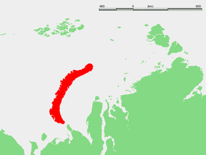
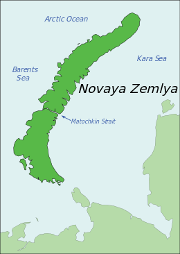 Map of Novaya Zemlya | |
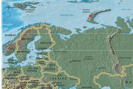 Location of Novaya Zemlya, including the site of the Tsar Bomba detonation | |
| Geography | |
| Location | Arctic Ocean |
| Coordinates | 74°N 56°E / 74°N 56°ECoordinates: 74°N 56°E / 74°N 56°E |
| Major islands | 2 |
| Area | 90,650 km2 (35,000 sq mi) |
| Highest elevation | 1,547 m (5,075 ft) |
| Administration | |
| Federal subject | Arkhangelsk Oblast |
| Largest settlement | Belushya Guba (pop. 1,972) |
| Demographics | |
| Population | 2,429 (2010) |
Novaya Zemlya (Russian: Но́вая Земля́, IPA: [ˈnovəjə zʲɪmˈlʲa], lit. the new land), also known as Nova Zembla (especially in Dutch), is an archipelago in the Arctic Ocean in northern Russia and the extreme northeast of Europe, the easternmost point of Europe lying at Cape Flissingsky on the Northern island. West of Novaya Zemlya is the Barents Sea, and to the east is the Kara Sea.
Novaya Zemlya is composed of two main islands, the northern Severny Island and the southern Yuzhny Island, which are separated by the Matochkin Strait. Administratively, it is incorporated as Novaya Zemlya District, one of the twenty-one in Arkhangelsk Oblast, Russia.[1] Municipally, it is incorporated as Novaya Zemlya Urban Okrug.[2]
Its population of Novaya Zemlys, as of the 2010 Census, was about 2,429, of which 1,972 resided in Belushya Guba,[3] an urban-type settlement that is the administrative center of Novaya Zemlya District. The population in 2002 was 2,716 (2002 Census).[4] The indigenous population (from 1872[5][6] to the 1950s when it was resettled to the mainland) consisted of about 50–300 Nenetses[7] who subsisted mainly on fishing, trapping, reindeer herding, polar bear hunting and seal hunting.[8][9] Natural resources include copper, lead, and zinc.[8]
Novaya Zemlya was a sensitive military area during the Cold War years, and parts of it are still used for airfields today. The Soviet Air Force maintained a presence at Rogachevo on the southern part of the southern island, on the westernmost peninsula (71°37′04″N 52°28′44″E / 71.61787°N 52.47884°E). It was used primarily for interceptor aircraft operations, but also provided logistical support for the nearby nuclear test area. Novaya Zemlya was the site of one of the two major nuclear test sites managed by the USSR, used for air drops and underground testing of the largest of Soviet nuclear bombs, in particular the October 30, 1961 air burst explosion of Tsar Bomba, the largest, most powerful nuclear weapon ever detonated.
History
The Russians knew of Novaya Zemlya from the 11th century, when hunters from Novgorod visited the area.[10] For western Europeans, the search for the Northern Sea Route in the 16th century led to its exploration.[10] The first visit from a west European was by Hugh Willoughby in 1553, and he met Russian ships from the already established hunting trade.[10] Dutch explorer Willem Barentsz reached the west coast of Novaya Zemlya in 1594, and in a subsequent expedition of 1596 rounded the Northern point and wintered on the Northeast coast.[11] (Barentsz died during the expedition, and may have been buried on the Northern island.[12]) During a later voyage by Fyodor Litke in 1821–1824, the west coast was mapped.[10] Henry Hudson was another explorer who passed through Novaya Zemlya while searching for the Northeast Passage.[13]
The islands were systematically surveyed by Pyotr Pakhtusov and Avgust Tsivolko during the early 1830s. The first permanent settlement was established in 1870 at Malye Karmakuly, which served as capital of Novaya Zemlya until 1924. Later the administrative center was transferred to Belushya Guba,[6][14] in 1935 to Lagernoe,[6] but then returned to Belushya Guba.
Small numbers of Nenets were resettled to Novaya Zemlya in the 1870s in a bid by Russia to keep out the Norwegians. This population, then numbering 298, was removed to the mainland in 1957 before nuclear testing began.[9][15][16][17]
In 1943, during World War II, Novaya Zemlya briefly served as a secret seaplane base for Nazi Germany's Kriegsmarine, to provide German surveillance of Allied shipping en route to Siberia. The seaplane base was established by U-255 and U-711, which were operating along the Northern coast of Soviet Russia as part of 13th U-boat Flotilla. Seaplane sorties were flown in August and September 1943.[18]
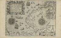 1599–1601 map of Novaya Zemlya
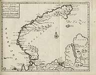 Map of Novaya Zemlya from 1720.
Nuclear testing
| Novaya Zemlya Test Site | |
|---|---|
 Map showing location of the site | |
| Type | Nuclear test site |
| Area |
land: 55,200 km2 (21,300 sq mi) water: 36,000 km2 (14,000 sq mi) |
| Site information | |
| Operator | Russian Federation (formerly Soviet Union) |
| Status | Active |
| Site history | |
| In use | 1955–present |
| Test information | |
| Subcritical tests | not known |
| Nuclear tests | 224 |
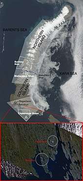
In July 1954, Novaya Zemlya was designated the Novaya Zemlya Test Site, construction of which began in October[19] and existed during much of the Cold War. "Zone A", Chyornaya Guba (70°42′N 54°36′E / 70.7°N 54.6°E), was used in 1955–1962 and 1972–1975.[19] "Zone B", Matochkin Shar (73°24′N 54°54′E / 73.4°N 54.9°E), was used for underground tests in 1964–1990.[19] "Zone C", Sukhoy Nos (73°42′N 54°00′E / 73.7°N 54.0°E), was used in 1958–1961 and was the site of the 1961 Tsar Bomba test, the most powerful nuclear weapon ever detonated.[19]
Other tests occurred elsewhere throughout the islands, with an official testing range covering over half of the landmass. In September 1961, two propelled thermonuclear warheads were launched from Vorkuta Sovetsky and Salekhard to target areas on Novaya Zemlya. The launch rocket was subsequently deployed to Cuba.[20]
1963 saw the implementation of the Limited Test Ban Treaty which banned most atmospheric nuclear tests.[21] The largest underground test in Novaya Zemlya took place on September 12, 1973, involving four nuclear devices of 4.2 megatons total yield. Although far smaller in blast power than the Tsar Bomba and other atmospheric tests, the confinement of the blasts underground led to pressures rivaling natural earthquakes. In the case of the September 12, 1973, test, a seismic magnitude of 6.97 on the Richter Scale was reached, setting off an 80 million ton avalanche that blocked two glacial streams and created a lake 2 kilometres (1.2 mi) in length.[21]
Over its history as a nuclear test site, Novaya Zemlya hosted 224 nuclear detonations with a total explosive energy equivalent to 265 megatons of TNT.[19] For comparison, all explosives used in World War II, including the detonations of two US nuclear bombs, amounted to only two megatons.[21]
In 1988–1989, glasnost helped make the Novaya Zemlya testing activities public knowledge,[19] and in 1990 Greenpeace activists staged a protest at the site.[22] The last nuclear test explosion was in 1990 (also the last for the entire Soviet Union and Russia). The Ministry for Atomic Energy has performed a series of subcritical underwater nuclear experiments near Matochkin Shar each autumn since 1998.[23] These tests reportedly involve up to 100 grams (3.5 oz) of weapons-grade plutonium.[24]
Geography
Novaya Zemlya is an extension of the Northern part of the Ural Mountains,[25] and the interior is mountainous throughout.[10] It is separated from the mainland by the Kara Strait.[10] Novaya Zemlya consists of two major islands, separated by the narrow Matochkin Strait, as well as a number of smaller islands. The two main islands are:
- Severny (Northern), which has a large ice cap, the Severny Island ice cap, as well as many active glaciers.
- Yuzhny (Southern), which is largely unglaciated and has a tundra landscape.[8]
The coast of Novaya Zemlya is very indented, and it is the area with the largest number of fjords in the Russian Federation. Novaya Zemlya separates the Barents Sea from the Kara Sea. The total area is about 90,650 square kilometers (35,000 sq mi). The highest mountain is located on the Northern island and is 1,547 meters (5,075 ft) high.[26]
Compared to other regions that were under large ice sheets during the last glacial period, Novaya Zemlya shows relatively little isostatic rebound. Possibly this is indebted to a counter-effect created by the growth of glaciers during the last few thousand years.[27]
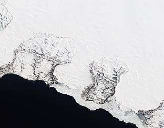 Natural-color satellite image of the Nordenskiöld Glacier group. East coast, Severny
 Barents Bay (Willem Barents' gravesite; 76°27’N, 68°42’E)
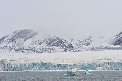 Inostrantsev Glacier terminus (76°28‘N, 66°5‘E)
 Cape Zhelaniya (Northernmost cape of Severny; 76°57’N, 68°35’E)
Environment
The ecology of Novaya Zemlya is influenced by its severe climate, but the region nevertheless supports a diversity of biota. One of the most notable species present is the polar bear, whose population in the Barents Sea region is genetically distinct from other polar bear subpopulations.[28]
Climate
| Climate data for Malye Karmakuly, Novaya Zemlya | |||||||||||||
|---|---|---|---|---|---|---|---|---|---|---|---|---|---|
| Month | Jan | Feb | Mar | Apr | May | Jun | Jul | Aug | Sep | Oct | Nov | Dec | Year |
| Record high °C (°F) | 2.6 (36.7) |
1.7 (35.1) |
2.0 (35.6) |
7.8 (46) |
17.6 (63.7) |
22.2 (72) |
28.3 (82.9) |
23.8 (74.8) |
16.5 (61.7) |
9.7 (49.5) |
4.5 (40.1) |
2.5 (36.5) |
28.3 (82.9) |
| Average high °C (°F) | −10.9 (12.4) |
−11.5 (11.3) |
−9.1 (15.6) |
−6.7 (19.9) |
−1.4 (29.5) |
4.9 (40.8) |
10.3 (50.5) |
9.0 (48.2) |
5.5 (41.9) |
−0.1 (31.8) |
−4.8 (23.4) |
−8.1 (17.4) |
−1.9 (28.6) |
| Daily mean °C (°F) | −14.1 (6.6) |
−14.7 (5.5) |
−12.2 (10) |
−9.9 (14.2) |
−3.7 (25.3) |
2.5 (36.5) |
7.3 (45.1) |
6.8 (44.2) |
3.7 (38.7) |
−1.8 (28.8) |
−7.1 (19.2) |
−11.1 (12) |
−4.5 (23.9) |
| Average low °C (°F) | −17.3 (0.9) |
−17.9 (−0.2) |
−15.2 (4.6) |
−13.0 (8.6) |
−5.8 (21.6) |
0.7 (33.3) |
5.1 (41.2) |
4.9 (40.8) |
2.1 (35.8) |
−4.0 (24.8) |
−9.9 (14.2) |
−14.1 (6.6) |
−7.0 (19.4) |
| Record low °C (°F) | −36.0 (−32.8) |
−37.4 (−35.3) |
−40.0 (−40) |
−29.9 (−21.8) |
−25.9 (−14.6) |
−9.6 (14.7) |
−2.8 (27) |
−1.7 (28.9) |
−9.9 (14.2) |
−21.1 (−6) |
−29.1 (−20.4) |
−36.2 (−33.2) |
−40.0 (−40) |
| Average precipitation mm (inches) | 30 (1.18) |
26 (1.02) |
24 (0.94) |
20 (0.79) |
15 (0.59) |
23 (0.91) |
36 (1.42) |
31 (1.22) |
39 (1.54) |
35 (1.38) |
24 (0.94) |
33 (1.3) |
336 (13.23) |
| Average rainy days | 1 | 1 | 1 | 1 | 3 | 10 | 15 | 17 | 19 | 9 | 3 | 2 | 82 |
| Average snowy days | 18 | 18 | 19 | 17 | 17 | 10 | 1 | 1 | 6 | 17 | 19 | 20 | 163 |
| Average relative humidity (%) | 78 | 77 | 77 | 76 | 78 | 81 | 83 | 83 | 85 | 82 | 79 | 78 | 80 |
| Mean monthly sunshine hours | 0 | 25 | 107 | 215 | 189 | 173 | 229 | 143 | 73 | 40 | 3 | 0 | 1,197 |
| Source #1: Pogoda.ru.net[29] | |||||||||||||
| Source #2: NOAA (sun 1961–1990)[30] | |||||||||||||
See also
References
Notes
- ↑ Law #65-5-OZ
- ↑ Law #258-vneoch.-OZ
- ↑ Russian Federal State Statistics Service (2011). "Всероссийская перепись населения 2010 года. Том 1" [2010 All-Russian Population Census, vol. 1]. Всероссийская перепись населения 2010 года (2010 All-Russia Population Census) (in Russian). Federal State Statistics Service. Retrieved June 29, 2012.
- ↑ Russian Federal State Statistics Service (May 21, 2004). "Численность населения России, субъектов Российской Федерации в составе федеральных округов, районов, городских поселений, сельских населённых пунктов – районных центров и сельских населённых пунктов с населением 3 тысячи и более человек" [Population of Russia, Its Federal Districts, Federal Subjects, Districts, Urban Localities, Rural Localities—Administrative Centers, and Rural Localities with Population of Over 3,000] (XLS). Всероссийская перепись населения 2002 года [All-Russia Population Census of 2002] (in Russian). Retrieved August 9, 2014.
- ↑ "Новая земля - история заселения". Belushka.virtbox.ru. Retrieved 2012-09-27.
- 1 2 3 "Новая земля в 1917—1941 гг". Belushka.virtbox.ru. Retrieved 2012-09-27.
- ↑ "Microsoft Word - North Test Site _FINAL_.doc" (PDF). Retrieved 2012-09-27.
- 1 2 3 Novaya Zemlya in: "The Columbia Encyclopedia, 6th ed". Retrieved 2006-10-14.
- 1 2 Ядерные испытания СССР. Том 1. Глава 2, p. 58.
- 1 2 3 4 5 6 Novaya Zemlya in: "Encyclopædia Britannica (11th ed.)". 1911. Archived from the original on October 17, 2007. Retrieved 2006-10-14.
- ↑ Whitfield, Peter (1998). New Found Lands: Maps in the History of Exploration. UK: Routledge. ISBN 0-415-92026-4.
- ↑ "Search for Barents: Evaluation of Possible Burial Sites on North Novaya Zemlya, Russia", Jaapjan J. Zeeberg et al., Arctic Vol. 55, No. 4 (December 2002) p. 329–338
- ↑ Henry Hudson in: Microsoft Encarta Online Encyclopedia 2006. Archived from the original on November 1, 2009. Retrieved 2006-10-14.
- ↑ "Health, science and education, history and trade among others - news review from the Arkhangelsk region". Barents.fi. 2005-08-03. Retrieved 2012-09-27.
- ↑ "Nenets", Arctic Network for the Support of the Indigenous Peoples of the Russian Arctic
- ↑ "The Nenets", The Red Book of the Peoples of the Russian Empire
- ↑ "Nuclear Free Seas" Archived January 10, 2009, at the Wayback Machine., Greenpeace
- ↑ Warship International No. 3, 1987, p. 318.
- 1 2 3 4 5 6 Khalturin, Vitaly I.; Rautian, Tatyana G.; Richards, Paul G.; Leith, William S. (2005). "A Review of Nuclear Testing by the Soviet Union at Novaya Zemlya, 1955–1990" (PDF). Science and Global Security. 13 (1): 1–42. doi:10.1080/08929880590961862. Archived from the original (PDF) on September 8, 2006. Retrieved 2006-10-14.
- ↑ "Testing the Kosmos 2 rocket". Astronautix.com. Archived from the original on July 8, 2012. Retrieved September 27, 2012.
- 1 2 3 Pratt, Sara (2005-11-28). "Frozen in Time: A Cold War Relic Gives up its Secrets". Lamont-Doherty Earth Observatory, Columbia University. Retrieved 2006-10-14.
- ↑ "The early history of Greenpeace Russia". Greenpeace Russia. Retrieved 2006-10-14.
- ↑ Jasinski, Michael; Chuen, Cristina; Ferguson, Charles D. (October 2002). "Russia: Of truth and testing". Bulletin of the Atomic Scientists . 58 (5): 60–65. Retrieved 2009-09-22. External link in
|journal=(help) - ↑ "Russia: Central Test Site, Novaya Zemlya". Nuclear Threat Initiative. 2003-07-30. Retrieved 2006-10-14.
- ↑ "Novaya Zemlya, Northern Russia". NASA. Archived from the original on October 11, 2006. Retrieved October 14, 2006.
- ↑ Russian military mapping. The highest point is located at 75°10′N 57°50′E / 75.167°N 57.833°E
- ↑ Feldskaar, Willy; Amantov, Aleksey (August 21, 2017). "Liten landheving på Novaya Zemlya?". geoforskning.no (in Norwegian). Retrieved April 29, 2016.
- ↑ C. Michael Hogan (2008) Polar Bear: Ursus maritimus, Globaltwitcher.com, ed. Nicklas Stromberg Archived December 24, 2008, at the Wayback Machine.
- ↑ "Weather and Climate-The Climate of Malye Karmakuly" (in Russian). Weather and Climate (Погода и климат). Retrieved 27 February 2016.
- ↑ "Malye Karmakuly Climate Normals 1961–1990". National Oceanic and Atmospheric Administration. Retrieved 27 February 2016.
Literature
- Gerrit de Veer, Nova Zembla, written 1598, published 1996
- Vladimir Nabokov, "The Refrigerator Awakes" (1942), line 27
- Ian Fleming, In "The Living Daylights" (1966), Agent 272 is holed up in Novaya Zemlya
- Clive Cussler, Raise the Titanic! (1976), features a U.S. plan to recover a rare element vital to protecting the U.S. in the Cold War, an element found on Novaya Zemlya (where a U.S. spy and a Soviet guard clash), but now believed to be in the wreck of the RMS Titanic.
- Laurence Sterne, 1761, The Life & Opinions of Tristram Shandy, Gentleman, Book III, Chapter Twenty
Sources
- Архангельское областное Собрание депутатов. Областной закон №65-5-ОЗ от 23 сентября 2009 г. «Об административно-территориальном устройстве Архангельской области», в ред. Областного закона №232-13-ОЗ от 16 декабря 2014 г. «О внесении изменений в отдельные Областные Законы в сфере осуществления местного самоуправления и взаимодействия с некоммерческими организациями». Вступил в силу через десять дней со дня официального опубликования. Опубликован: "Волна", №43, 6 октября 2009 г. (Arkhangelsk Oblast Council of Deputies. Oblast Law #65-5-OZ of September 23, 2009 On the Administrative-Territorial Structure of Arkhangelsk Oblast, as amended by the Oblast Law #232-13-OZ of December 16, 2014 On Amending Various Oblast Laws Dealing with the Process of Municipal Self-Government and Relations with Non-Profit Organizations. Effective as of the day which is ten days after the official publication.).
- Архангельское областное Собрание депутатов. Областной закон №258-внеоч.-ОЗ от 23 сентября 2004 г. «О статусе и границах территорий муниципальных образований в Архангельской области», в ред. Областного закона №224-13-ОЗ от 16 декабря 2014 г. «Об упразднении отдельных населённых пунктов Соловецкого района Архангельской области и о внесении изменения в статью 46 Областного закона "О статусе и границах территорий муниципальных образований в Архангельской области"». Вступил в силу со дня официального опубликования. Опубликован: "Волна", №38, 8 октября 2004 г. (Arkhangelsk Oblast Council of Deputies. Oblast Law #258-vneoch.-OZ of September 23, 2004 On the Status and Borders of the Territories of the Municipal Formations in Arkhangelsk Oblast, as amended by the Oblast Law #224-13-OZ of December 16, 2014 On Abolishing Several Inhabited Localities in Solovetsky District of Arkhangelsk Oblast and on Amending Article 46 of the Oblast Law "On the Status and Borders of the Territories of the Municipal Formations in Arkhangelsk Oblast". Effective as of the day of the official publication.).
Further reading
- Serebryanny, Leonid (June 1997). "The colonization and peoples of Novaya Zemlya then and now". Nationalities Papers. 25 (2): 301–309. doi:10.1080/00905999708408505.
External links
| Wikimedia Commons has media related to Novaya Zemlya. |
| Wikivoyage has a travel guide for Novaya Zemlya. |
- Novaya Zemlya information portal
- Selected satellite views of nuclear test site Novaya Zemlya (global security).
- Environment, climate change, and history of exploration (Barents' wintering).
- Rozenberg Publishers - Climate and glacial history of the Novaya Zemlya Archipelago, Russian Arctic
- Nuclear tests in Novaya Zemlya, International Atomic Energy Agency Department of Nuclear Safety and Security.
| Authority control |
|---|