Ngwavuma River
| Ngwavuma River | |
| Inguavuma, Ingwavuma or Nggwavuma | |
| River | |
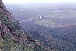 View from Border Cave over Ingwavuma River | |
| Name origin: From the Zulu name for Elaeodendron transvaalense, a tree whose bark is a fever remedy; possibly also 'the growling one' referring to the sound the river makes when passing through a ravine.[1] | |
| Countries | Swaziland, South Africa |
|---|---|
| Source | |
| - location | SW Swaziland |
| Mouth | Phongolo River |
| - elevation | 34 m (112 ft) |
| - coordinates | 26°57′42″S 32°17′39″E / 26.96167°S 32.29417°ECoordinates: 26°57′42″S 32°17′39″E / 26.96167°S 32.29417°E |
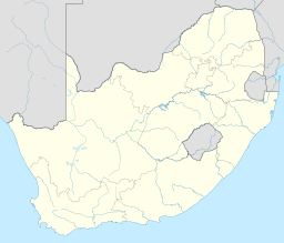 Location of the Ngwavuma River mouth | |
The Ngwavuma[2] is a river in Swaziland and KwaZulu-Natal Province in southern Africa. It is also known as the Inguavuma, Ingwavuma, Ingwovuma, and Nggwavuma, and is one of the five major rivers in Swaziland.[3] It arises in southwestern Swaziland and flows eastward. It is a tributary of the Pongola River.[4]
The principal towns in Swaziland along the Ngwavuma are Nhlangano and Nsoko.[3]
Notes
- ↑ Dictionary of Southern African Place Names
- ↑ Ngwavuma (Approved) at GEOnet Names Server, United States National Geospatial-Intelligence Agency
- 1 2 Ünver, Olcay, ed. (2009). "Swaziland". The United Nations World Water Development Report 3: Facing the Challenges. London: Earthscan for World Water Assessment Programme, UNESCO. p. 9. ISBN 978-1-84407-840-0.
- ↑ Usuthu/Mhlatuze WMA 6
External links
- Ngwavuma River, Swaziland - Satellite View centered on the mouth of the river in KwaZulu-Natal from satelliteviews.net
This article is issued from
Wikipedia.
The text is licensed under Creative Commons - Attribution - Sharealike.
Additional terms may apply for the media files.