Natzschung
| Natzschung | |
|---|---|
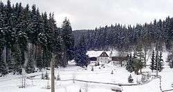 Valley of Natzschung river between Rübenau and Rothental. | |
| Country | Czech Republic; Saxony, Germany |
| Physical characteristics | |
| Main source |
near Načetín 820 m (2,690 ft) 50°33′01″N 13°16′12″E / 50.5502°N 13.2700°E |
| River mouth |
Flöha, Olbernhau 468 m (1,535 ft) 50°39′03″N 13°22′13″E / 50.6508°N 13.3702°ECoordinates: 50°39′03″N 13°22′13″E / 50.6508°N 13.3702°E |
| Length | 16.5 km (10.3 mi) |
| Basin features | |
| Progression | Flöha→ Zschopau→ Freiberger Mulde→ Mulde→ Elbe→ North Sea |
| Basin size | 80.3 km2 (31.0 sq mi) |
The Natzschung (Czech: Načetínský potok) is a river in Bohemia (Czech Republic) and Saxony (Germany). It is a left tributary of the Flöha, which it joins in Olbernhau. For much of its length it forms the border between Czech Republic and Germany.
See also
This article is issued from
Wikipedia.
The text is licensed under Creative Commons - Attribution - Sharealike.
Additional terms may apply for the media files.