Naroulia District
| Naroulia District Нараўлянскі раён (be) Наровлянский район (ru) | ||
|---|---|---|
| ||
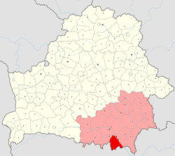 Location of Naroulia Raion within Gomel Region and Belarus | ||
| Coordinates: 51°48′N 29°30′E / 51.800°N 29.500°ECoordinates: 51°48′N 29°30′E / 51.800°N 29.500°E | ||
| Country |
| |
| Voblast |
| |
| Seat | Naroulia | |
| Government | ||
| • Ispolkom | ? | |
| Area | ||
| • Total | 1,588.82 km2 (613.45 sq mi) | |
| Population (2016)[1] | ||
| • Total | 10,563 | |
| Website | Official website | |

Naroulia Rajon or Naraulianski Rajon (Belarusian: Нараўлянскі раён, Russian: Наровлянский район) is an administrative subdivision, a rajon of Homiel Voblast, in Belarus. Its administrative seat is the town of Naroulia.
Geography
The district includes the town of Naroulia, 6 rural councils (Selsovets), and several villages. Following the 1986 Chernobyl disaster, it is partially included in the Polesie State Radioecological Reserve.[2][3]
See also
References
- ↑ (in Russian) Source: BelStat 2016
- ↑ Polesie Radio-ecological Zapovednik (APB BirdLife Belarus)
- ↑ 253459229 Polesie State Radioecological Reserve on OpenStreetMap
External links
![]()
| Districts (raions) |  | |
|---|---|---|
| Cities | ||
This article is issued from
Wikipedia.
The text is licensed under Creative Commons - Attribution - Sharealike.
Additional terms may apply for the media files.