Narborough, Leicestershire
| Narborough | |
|---|---|
 Narborough Hall | |
 Narborough Narborough shown within Leicestershire | |
| Population | 8,448 (parish; 2011 Census) |
| OS grid reference | SP540975 |
| Civil parish |
|
| District | |
| Shire county | |
| Region | |
| Country | England |
| Sovereign state | United Kingdom |
| Post town | Leicester |
| Postcode district | LE19 |
| Dialling code | 0116 |
| Police | Leicestershire |
| Fire | Leicestershire |
| Ambulance | East Midlands |
| EU Parliament | East Midlands |
| UK Parliament | |
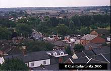
Narborough is a large village and civil parish in the Blaby district of Leicestershire, England, located around 6 miles (9.7 km) southwest of Leicester. The population of the civil parish (including Littlethorpe) at the 2011 census was 8,498.[1]
The name is derived from the Old English north burh, meaning "north stronghold".[2] At the 2001 Census, the parish had a population of 8,402.[3]
Surrounding villages include Enderby, Whetstone, Littlethorpe, Cosby, and Huncote.
Location
Narborough is situated on or near several major transport corridors. The M1 motorway passes through the east of Narborough, and the Leicester to Birmingham railway line runs beside the River Soar on its way through the village. Coventry Road in the village centre runs along the course of the Fosse Way (Roman road), which then joins back onto the present course of the B4114 link from Birmingham to Leicester.
Narborough is often split into two distinct parts, the (old) village core to the South and the newer Pastures estate to the north east. These areas are separated by the B4114 which runs through the middle of the two areas.
The village centre and The Pastures area are served by the number 50 bus operated by Arriva Midlands, linking it directly with Enderby, Croft (one bus per day mon-sat), Fosse Shopping Park, and Leicester city centre. In addition, the village centre is served by the hourly centrebus 140 to Broughton Astley, Lutterworth, and Rugby; meanwhile Arriva Midlands service 50A connects the village centre with Huncote and Croft, Fosse Shopping Park, and Leicester city centre.
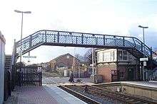
Narborough railway station, with its level crossing, is situated in the village centre, linking the village with South Wigston and Leicester to the north, and Hinckley, Nuneaton, Coventry, and Birmingham in the south and west.
Amenities
The village contains many amenities including two doctors' surgeries, a dentist, two banks, several hairdressers, a beauty salon, a Post Office, two estate agents and two chemists. There are also four newsagents, a bakery, a Chinese takeaway, a pizza takeaway and a fish and chip shop. Narborough also boasts two small supermarkets, a Tesco Express and a Central England Co-operative, and two pubs: The Copt Oak and outside the village centre and Narborough Arms within it. Two other pubs have since been converted into Indian Restaurants: "The Bell" is now Spice 45 Indian restaurant and the "Dovecote" was converted to the "Monsoon Indian Restaurant" (after a long closure the building has been taken over and is now called "The Dovecote"). A third property has been converted into an Indian restaurant/hotel: the Heritage Hotel and Restaurant can be found on Leicester Road.
To the north-east of the village lies Carlton Park, a business park that included the headquarters of Alliance & Leicester, who employed over 1,800 people locally. Carlton Park also has a Racquets and Health Club, David Lloyd (formerly Next Generation), which opened in the summer of 2006 . Near to the village centre are the Blaby District Council offices. As well as Greystoke Primary School in the village, The Pastures Primary and Red Hill field Primary School are the two other primary schools serving the village. Pupils from these schools will generally go on to Brockington College in Enderby.
There is a railway station in the village.
Religion
Narborough also has a Congregational Church situated on School Lane and a Catholic church, St. Pius X, on Leicester Road.
Narborough has been home to The Buddhist House, HQ for the Amida Trust, a Pureland Buddhist school, since 2001.
Crime
Narborough was where Colin Pitchfork raped and murdered a 15-year-old schoolgirl in 1983.[4] He also killed a girl of the same age in nearby Enderby in 1986. Initially a 17-year-old youth was suspected, and even confessed to one of the murders, but DNA testing cleared him.[5] Following what was the first mass DNA screening of an entire community, Pitchfork was the first person to be arrested and convicted of a crime using DNA profiling.[6][7][8][9]
See also
References
- ↑ "Civil Parish population 2011". Neighbourhood Statistics. Office for National Statistics. Retrieved 16 June 2016.
- ↑ Mills, A.D. (2003). A Dictionary of British Place-Names. Oxford University Press. ISBN 978-0-1915-7847-2.
- ↑ "Key Figures for 2001 Census: Narborough". Office for National Statistics (Neighbourhood Statistics). Retrieved 29 August 2015.
- ↑ BBC News - 20 Years of DNA Evidence
- ↑ Forensic Science Service - Colin Pitchfork - first murder conviction on DNA evidence also clears the prime suspect Archived 14 December 2006 at the Wayback Machine.
- ↑ Leicester University - Genetics History
- ↑ Canadian National DNA Bank - Colin Pitchfork
- ↑ Times Online - The DNA scientist who made individuals of us all
- ↑ The Telegraph - Great Britons: How the DNA dude changed life
External links
| Wikimedia Commons has media related to Narborough, Leicestershire. |
- The Official Narborough Village Website
- Narborough Village Website
- Parish Council
- Narborough Congregational Church Website
- Greystoke Primary School Narborough Website
- Narborough Hall Website
Towns and villages of Blaby District | ||
|---|---|---|
| Towns |  | |
| Large villages | ||
| Small villages | ||
| Hamlets | ||