Nagold Dam
| Nagold Dam | |
|---|---|
 | |
| Location | Freudenstadt |
| Coordinates | 48°33′46″N 8°30′03″E / 48.5627°N 8.5009°ECoordinates: 48°33′46″N 8°30′03″E / 48.5627°N 8.5009°E |
| Construction began | 1965–1970 |
| Dam and spillways | |
| Impounds | Nagold |
| Height | 32.10 m (105.3 ft) |
| Height (foundation) | 35 m (115 ft) |
| Length | 235 m (771 ft) |
| Elevation at crest | 552.10 m (1,811.4 ft) |
| Width (crest) | 9.2 m (30 ft) |
| Width (base) | 145 m (476 ft) |
| Dam volume | 311,000 m³ |
| Spillway capacity | 129 m/s ? |
| Reservoir | |
| Total capacity | 5.065 M m³ |
| Active capacity | 4.50 M m³ |
| Catchment area | 39 sq km |
| Surface area | 548.50 m |
| Maximum length | 2.050 km |
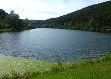
The Nagold Dam (German: Nagoldtalsperre, also Erzgrube) in the German state of Baden-Württemberg, was built between 1965 and 1970, and provides flood and drought protection in the Nagold valley. It lies within the county of Freudenstadt and was taken into service in 1971. The nearest settlement is Seewald-Erzgrube.
Leisure
Its location in the middle of a 650 hectare protected area in the Black Forest makes the impounded Nagold Reservoir a popular recreation area. From 1 April to 30 September, sailing is permitted on the lake. The dam has a pre-dam about 800 metres above the head of the reservoir.
Gallery
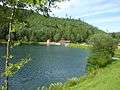 Pre-dam
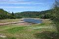 Lower part of the reservoir at low water
See also
Literature
- Peter Franke, Wolfgang Frey: Talsperren in der Bundesrepublik Deutschland, DNK – DVWK 1987, ISBN 3-926520-00-0.
External links
This article is issued from
Wikipedia.
The text is licensed under Creative Commons - Attribution - Sharealike.
Additional terms may apply for the media files.