Minbya
| Minbya မင်းပြား | |
|---|---|
| Town | |
|
| |
 Minbya Location in Myanmar (Burma) | |
| Coordinates: 20°09′00″N 92°54′00″E / 20.15000°N 92.90000°E | |
| Country |
|
| Division |
|
| District | Mrauk-U District |
| Township | Minbya Township |
| Population (2014 Census) | |
| • Total | 169,208[1] |
| • Ethnicities | Rakhine |
| • Religions | Buddhism |
| Time zone | UTC+6.30 (MMT) |
| • Summer (DST) | UTC20° 9' 0" North, 92° 54' 0" East |
| Area code(s) | 42, 43 |
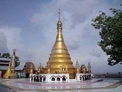
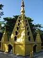
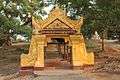
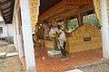
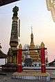
Minbya (Burmese: မင်းပြားမြို့, pronounced [mɪ́ɴbjá mjo̰]) is a town in Rakhine State, in the westernmost part of Myanmar (Burma). It is located along the Lay Myo River and foothill of Kyein Range. Kyein Taung Pagoda is one of the prominent Pagoda in Rakhine State. Ramaung Bridge is also well-known.Minbya is convenient in transportation as Sittwe-Yangon high-way road lies near Minbya. Ga Rim Gian is a nice place to visit with the pleasant sights.
Education
There are three Basic Education High Schools in the town.
Natural disasters
On 15 June 2010, strong rains destroyed more than 25 buildings, including houses, school buildings, and a mosque. Close to 200 people were housed in mosques of several nearby villages.[2]
On 12 November 2011, all 567 permanent shops of the Minbya central market were destroyed in a fire accident.
[3] During the last weekend of July 2015, there was a heavy rain and cause the flooding and then this situation was worse as the Cyclone Komen hit the Arakan Coastal on 30 July. It caused great damages in urban and rural area. Many farms were destroyed. After flooding, many civil charity group were came to aid the rural residents. This flooding was also taking place in Mrauk-Oo, Kyauk Taw townships.
External links
References
- ↑ Census Report. The 2014 Myanmar Population and Housing Census. 2. Naypyitaw: Ministry of Immigration and Population. May 2015. p. 60.
- ↑ Myanmar: Downpours, strong winds cause death, injury, damage to houses, roads, railroad sections, floods, landslides State, departments, Tatmadawmen, NGOs and wellwishers render assistance for relief and rehabilitation
- ↑ "Archived copy" (PDF). Archived from the original (PDF) on 2010-11-22. Retrieved 2013-11-20. Page 6 Col 1
Capital: Sittwe | ||
| Kyaukpyu District |  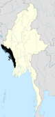 | |
| Maungdaw District | ||
| Sittwe District | ||
| Thandwe District |
| |
| Mrauk-U District | ||
| Main cities and towns | ||
Coordinates: 20°22′N 93°16′E / 20.367°N 93.267°E