Mulde
| Mulde | |
|---|---|
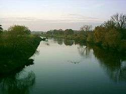 The Mulde near Bad Düben | |
| Country | Germany |
| Physical characteristics | |
| Main source |
Zwickauer Mulde and Freiberger Mulde 63 m (207 ft) |
| River mouth |
Elbe 51°52′08″N 12°13′52″E / 51.86889°N 12.23111°ECoordinates: 51°52′08″N 12°13′52″E / 51.86889°N 12.23111°E |
| Length | 124 km (77 mi) or 290 km (180 mi) including Zwickauer Mulde |
| Basin features | |
| Progression | Elbe→ North Sea |
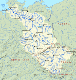
The Mulde (German pronunciation: [ˈmʊldə]) is a river in Saxony and Saxony-Anhalt, Germany. It is a left tributary of the Elbe and is 124 kilometres (77 mi) long.
The river is formed by the confluence, near Colditz, of the Zwickauer Mulde (running through Zwickau) and the Freiberger Mulde (with Freiberg on its banks), both rising from the Ore Mountains. From here the river runs northwards through Saxony (Grimma, Wurzen, Eilenburg, Bad Düben) and Saxony-Anhalt (Jeßnitz and Dessau, the old capital of Anhalt). The Mulde flows into the Elbe 3 kilometres (2 mi) north of Dessau.[1]
In August 2002 a flood caused severe damage, that even endangered the UNESCO World Heritage Site "Dessau-Wörlitzer Gartenreich" and the city Dessau. Especially the cities of Döbeln and Grimma suffered from the damages of the flood.
Its name could be derived from Old German (possibly Gothic) "Mulda" (𐌼ᚢ𐌻ᛞᚨ), meaning "dust" and a cognate of English "mould"). But more possibly it is related to the German "mahlen" which means "to mill". Therefore, Mulde probably means "the milling river" and corresponds to the great number of water mills driven by the river in former times. Nowadays, there are hydroelectric power stations in use.
References

Notes
| Wikimedia Commons has media related to Mulde. |