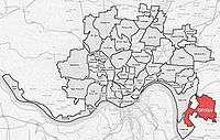
Mount Washington, Cincinnati
| Mount Washington | |
|---|---|
 Mount Washington is a neighborhood of Cincinnati, Ohio. |
Mount Washington is a neighborhood on the east side of Cincinnati, Ohio, United States. It is located about ten minutes east of Downtown via Columbia Parkway and Beechmont Avenue, or a slightly longer drive via Riverside Drive (formerly Eastern Avenue) and Kellogg Avenue, to Salem Avenue and up Sutton Avenue or Beacon Street. As one of Cincinnati's 52 neighborhoods, Mount Washington lies within the city corporation limits, and borders the neighborhoods of California, Linwood, and the East End, as well as unincorporated Anderson Township, Hamilton County, Ohio. It is served by the 24, 30X, and 81X Metro[1] bus routes.
The population was 11,711 at the 2010 census.[2]
History
Mount Washington was laid out in 1846 and received its city rights in 1867. The community was annexed by the City of Cincinnati in 1911.[3][4]
Business district
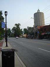
Mount Washington is home to numerous small businesses, many of them located along Beechmont Avenue / Ohio State Route 125 in the main neighborhood business district, "The Mount Washington Water Tower District" is sometimes referred to as "Uptown" as a means of distinguishing it from other business districts, including Downtown Cincinnati and the two other districts in Mount Washington.
Businesses include Water Tower Fine Wines (a retail wine shop with weekly tastings and appetizers), Ramundo's Pizza, Sweets & Meats BBQ (a locally owned and award-winning take out restaurant), Mt. Washington Creamy Whip & Bakery (seasonal), Mt. Washington Jewelry, and Mr. Lock locksmith, as well as local outlets of Wendy's, LaRosa's Pizza, PNC Bank, Fifth Third Bank, Walgreens, and Kroger (headquartered in Cincinnati). Gold Star Chili was started in Mount Washington with the purchase of Hamburger Heaven in 1965, although the original location no longer exists. A recipe for Cincinnati chili was included in the sale.
Community organizations
Mt. Washington Community Council (MWCC) is the official representative voice of the neighborhood to the City of Cincinnati. MWCC ensures that neighborhood development responds to the needs and goals of its citizens. MWCC is also a vehicle for communication and engagement.[5] Public meetings are held the third Wednesday of every month at the Mt. Washington Recreation Center.[6]
The Mt. Washington Community Urban Redevelopment Corporation[7] represents the member businesses in the neighborhood. Mt. Washington is also served by an active American Legion, Post 484,[8] and Masonic Lodge, Yeatman Lodge #162[9]
Beechmont Avenue reconstruction and evolution
Beechmont Avenue in western Mount Washington, prior to the 2002-2003 widening, featured reversible lanes. When the street was widened, two additional lanes were added between the western Corporation Line and Wasigo Drive (to create a dual turn lane), with one additional lane between Wasigo Drive and Corbly Street. Sidewalks, trees and curbs were also added along the route as well as a bike lane into the business district.
Housing
Throughout the 1980s, the growth of large apartment complexes and subsequent lack of investment into these buildings strained the neighborhood's image. Recent zoning has helped to protect the mostly residential nature of Beechmont Avenue, while many of the large apartment complexes have not aged well and many are owned by absentee landlords who do not maintain them properly.
Mount Washington contains historic homes and distinctive architecture. Housing stock in the neighborhood is diverse, with values ranging from modest bungalows to million dollar estates. The neighborhood is home to Victorian-era homes, particularly along minor arterials, such as Beacon Street, Mears Avenue, Cambridge Avenue and Sutton Avenue. Many streets between these minor arterials were developed in the 1920s and 1930s, ranging from modest bungalows and Cape Cods to small colonial houses. Kopf and Bressler's developments on Wilaray Terrace, Honeysuckle Lane, and Honeysuckle Drive are filled with 1940s and 1950s-era architect-designed custom-built homes. The Lower Salem area, located along Salem Avenue between Wayside and Kellogg Avenues, contains sprawling estates and large homes built between the 1930s and 1960s. Developments from the last decades of the 20th century include the George Mayer subdivision (Woodlark Drive and Thornbird Drive, connecting Mayland Drive to Mears Avenue); the Reserve of Turpin, a master-planned community; and portions of Berkshire Estates, which were built by Zaring Homes, and contain single-family homes and landominiums, as well as streets such as Adena Trail.
Schools
Three grade schools are located in Mount Washington:
- Sands Montessori (Corbly Street, Cincinnati Public Schools), a magnet school now housed in a new building (2011) on the site formerly housing the Eastern Hills Elementary and Junior High Schools
- Mt. Washington Elementary School (Mears Avenue), Built in 1859, later renovated in 2010.Cincinnati Public Schools
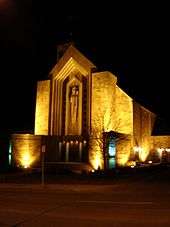
- Guardian Angels School (6539 Beechmont Avenue, Roman Catholic Archdiocese of Cincinnati). The Guardian Angels Campus, constructed in 1931, 1942, 1949, and 1963–1971, was designed by architect Edward J. Schulte.
The Archbishop McNicholas High School (Roman Catholic Archdiocese of Cincinnati) is also located in Mount Washington, across from Guardian Angels.
Mount Washington is also home to the Athenaeum of Ohio (Mt. St. Mary's Seminary of the West), located at the eastern gateway to Mount Washington, the intersection of Beechmont Avenue and Burney Lane. The campus is owned by the Archdiocese of Cincinnati and is known for its architecture. Many of the records for the Archdiocese of Cincinnati are located at the campus library.
Parks
Cincinnati Park Board operates the 125-acre (0.51 km2) Stanbery Park on Oxford Avenue between Corbly Street and Crestview Place. This park is named after Brigadier General Sanford B. Stanbery, who was the highest-ranking officer from Hamilton County in World War I. The Tudor-style Stanbery house used to be located on park grounds, but was demolished as part of a park improvement program.
The park facilities include a paved walking area, hiking trails, playground equipment, and a picnic shelter.
Social Media
Mt. Washington has a large presence on social media.
References
- ↑ Metro
- ↑ "Mt. Washington Statistical neighborhood approximation". City of Cincinnati. p. 2. Retrieved 27 January 2018.
- ↑ Federal Writers' Project (1943). "Cincinnati, a Guide to the Queen City and Its Neighbors". p. 249. Retrieved 2013-05-04.
- ↑ Clarke, S. J. (1912). "Cincinnati, the Queen City, 1788-1912, Volume 2". The S. J. Clarke Publishing Company. p. 528. Retrieved 2013-05-20.
- ↑ http://choosecincy.com/Community-Development/Community-Resources/Community-Councils.aspx
- ↑ http://www.mwcc.org/events/
- ↑ Mt. Washington Community Urban Redevelopment Corporation
- ↑ American Legion, Post 484
- ↑ Yeatman Lodge #162
External links
- Mount Washington Community Council
- Guardian Angels School
- Mount Washington Baptist Church and Daycare
- City of Cincinnati
- Mount Washington Elementary School
- Sands Montessori Elementary School
Coordinates: 39°05′15″N 84°23′11″W / 39.08750°N 84.38639°W
| Neighborhoods |
| .png) | |||||||||||
|---|---|---|---|---|---|---|---|---|---|---|---|---|---|
| History |
| ||||||||||||
| Sports |
| ||||||||||||
| Education |
| ||||||||||||