Mount Waesche
| Mount Waesche | |
|---|---|
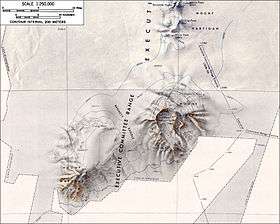 Topographic map of Mounts Sidley and Waesche | |
| Highest point | |
| Elevation | 3,292 m (10,801 ft) |
| Coordinates | 77°10′S 126°54′W / 77.167°S 126.900°W |
| Geography | |
| Location | Marie Byrd Land, Antarctica |
| Parent range | Executive Committee Range |
| Geology | |
| Mountain type | Shield volcano |
Mount Waesche is a large and prominent mountain of volcanic origin, standing immediately SW of Mount Sidley and marking the southern end of the Executive Committee Range in Marie Byrd Land, Antarctica. The feature is snow-covered except for rock exposures on the south and southwestern slopes. The volcano may have been active as late as the Holocene (Lough et al. [2013] report an associated mid-ice ash layer with an age of approximately 8,000 years) and may be only presently dormant.
Discovered by the United States Antarctic Service expedition on a flight, December 15, 1940, and named for V. Admiral Russell R. Waesche, United States Coast Guard, member of the Antarctic Service Executive Committee.
See also
Sources
- "Waesche". Global Volcanism Program. Smithsonian Institution.
- LeMasurier, W. E. (1990). Thomson, J. W, ed. Volcanoes of the Antarctic Plate and Southern Oceans. American Geophysical Union. p. 512 pp. ISBN 0-87590-172-7.
- U.S. Geological Survey Geographic Names Information System: Mount Waesche
- "Skiing the Pacific Ring of Fire and Beyond". Amar Andalkar's Ski Mountaineering and Climbing Site. 2007 [1997]. Retrieved 2005-01-14.
- Lough, A.; Wiens, D.; Barcheck, C.; Aster, R.; Nyblade, A.; Huerta, A.; Wilson, T. (17 November 2013). "Seismic detection of an active subglacial volcanic center in Marie Byrd Land, Antarctica". Nature Geoscience: 1031–1035. doi:10.1038/ngeo1992.
This article is issued from
Wikipedia.
The text is licensed under Creative Commons - Attribution - Sharealike.
Additional terms may apply for the media files.