Mount Martin (Alaska)
| Mount Martin. | |
|---|---|
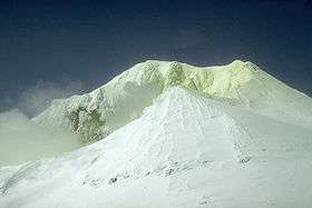 Summit crater of Mount Martin volcano, June 1990 | |
| Highest point | |
| Elevation | 6,112 ft (1,863 m) |
| Coordinates | 58°10′19″N 155°21′40″W / 58.172°N 155.361°W |
| Geography | |
| Location | Katmai National Park and Preserve, Alaska, U.S. |
| Parent range | Aleutian Range |
| Topo map | USGS Adak C-2 |
| Geology | |
| Mountain type | Stratovolcano |
| Volcanic arc/belt | Aleutian Arc |
| Last eruption | February 1953 |
Mount Martin is a stratovolcano, located on the Alaska Peninsula, United States. It is one of the volcanoes in the vicinity of the Valley of Ten Thousand Smokes. Although an eruption in 1953 is now considered questionable and no other confirmed eruptive activity has taken place at Mount Martin, there is intense fumarolic activity within its summit crater. The summit crater is also breached to the southeast. The 300 m (984 ft)-wide summit crater is often ice-free due to the geothermal heat and contains an intermittent acidic crater lake. The fumaroles in the summit crater produce extensive sulfur deposits.
The volcano is named for George C. Martin, who was the first person to visit the Valley of Ten Thousand Smokes after the 1912 eruption of Novarupta.
See also
Sources
- "Martin". Global Volcanism Program. Smithsonian Institution.
- Volcanoes of the Alaska Peninsula and Aleutian Islands-Selected Photographs