Mount Jackson (Montana)
| Mount Jackson | |
|---|---|
 Cloud cap over Mount Jackson | |
| Highest point | |
| Elevation | 10,052 ft (3,064 m) [1] |
| Prominence | 3,406 ft (1,038 m) [1] |
| Parent peak | Mount Cleveland[1] |
| Listing | Mountains in Flathead County, Montana |
| Coordinates | 48°36′02″N 113°43′19″W / 48.60056°N 113.72194°WCoordinates: 48°36′02″N 113°43′19″W / 48.60056°N 113.72194°W [2] |
| Geography | |
 Mount Jackson | |
| Parent range | Lewis Range |
| Topo map | USGS Mount Jackson, MT |
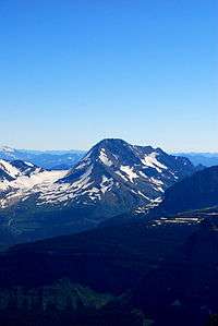
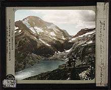
Mount Jackson (10,052 feet (3,064 m)) is located in the Lewis Range, Glacier National Park in the U.S. state of Montana.[3] Mount Jackson is the fourth tallest mountain in Glacier National Park and it is situated on the Continental Divide. Both the mountain and its namesake Jackson Glacier are easily seen from the Going-to-the-Sun Road. Harrison Glacier, the park's largest remaining glacier, is located on the mountain's southern flank.[1]
Mount Jackson with Jackson Glacier directly to the left of the mountain
Peak of Mount Jackson
See also
References
- 1 2 3 4 "Mount Jackson, Montana". Peakbagger.com. Retrieved 2010-08-29.
- ↑ "Mount Jackson". Geographic Names Information System. United States Geological Survey. Retrieved 2010-08-29.
- ↑ "Mount Jackson, Montana" (Map). TopoQuest (USGS Quad). Retrieved 2010-08-29.
This article is issued from
Wikipedia.
The text is licensed under Creative Commons - Attribution - Sharealike.
Additional terms may apply for the media files.