Freyberg Mountains

Freyberg Mountains
Freyberg Mountains in Antarctica
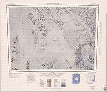
1:250,000 scale topographic map of Freyberg Mountains and Evans Névé.
The Freyberg Mountains (72°15′S 163°45′E / 72.250°S 163.750°E) are a group of mountains in Victoria Land, Antarctica, bounded by Rennick Glacier, Bowers Mountains, Black Glacier, and Evans Neve. Named for New Zealand's most famous General, Lord Bernard Freyberg, by the Northern Party of New Zealand Geological Survey Antarctic Expedition (NZGSAE), 1963-64.[1] This mountain group includes the Alamein Range. These topographical features all lie situated on the Pennell Coast, a portion of Antarctica lying between Cape Williams and Cape Adare.
Key mountains
- Mount Baldwin (72°15′S 163°18′E / 72.250°S 163.300°E) is a mountain 5 nautical miles (9 km) southeast of Smiths Bench, in the Freyberg Mountains. Named by Advisory Committee on Antarctic Names (US-ACAN) for T.T. Baldwin, transport specialist, a member of the United States Antarctic Research Program (USARP) Victoria Land Traverse Party which surveyed this area in 1959-60.[2]
- Buttress Peak (72°26′S 163°45′E / 72.433°S 163.750°E) is a peak at the east end of the central ridge of Gallipoli Heights. The descriptive name was suggested by P.J. Oliver, New Zealand Antarctic Research Program (NZARP) geologist who studied the peak, 1981-82.[3]
- Mount Jackman (72°24′S 163°15′E / 72.400°S 163.250°E) is a mountain, 1,920 m, standing 9 miles (14 km) south of Mount Baldwin. Named by US-ACAN for Warren A. Jackman, photographer, a member of the USARP Victoria Land Traverse Party which surveyed this area in 1959-60.[4]
- Mount Strandtmann (72°7′S 163°5′E / 72.117°S 163.083°E) is a mountain 3 nautical miles (6 km) north of Smiths Bench. Mapped by United States Geological Survey (USGS) from surveys and U.S. Navy air photos, 1960-64. Named by US-ACAN for Russell W. Strandtmann, biologist at McMurdo Station, summers 1966-67 and 1967-68.[5]
Features
Geographical features of Freyberg Mountains include:
Alamein Range
Gallipoli Heights
Russet Hills
Salamander Range
Other features
References
- ↑ "Freyberg Mountains". Geographic Names Information System. United States Geological Survey. Retrieved 2010-11-06.
- ↑ "Mount Baldwin". Geographic Names Information System. United States Geological Survey. Retrieved 2010-09-22.
- ↑ "Buttress Peak". Geographic Names Information System. United States Geological Survey. Retrieved 2010-10-24.
- ↑ "Mount Jackman". Geographic Names Information System. United States Geological Survey. Retrieved 2008-03-21.
- ↑ "Mount Strandtmann". Geographic Names Information System. United States Geological Survey. Retrieved 2010-11-01.
![]()
This article is issued from
Wikipedia.
The text is licensed under Creative Commons - Attribution - Sharealike.
Additional terms may apply for the media files.