Mount Gharat
| Mount Gharat (Mount Garet) | |
|---|---|
 Mount Gharat and Lake Letas. | |
| Highest point | |
| Elevation | 797 m (2,615 ft) |
| Prominence | 797 m (2,615 ft) |
| Coordinates | 14°16′S 167°30′E / 14.267°S 167.500°ECoordinates: 14°16′S 167°30′E / 14.267°S 167.500°E |
| Geography | |
| Location | Gaua, Banks Islands, Vanuatu |
| Geology | |
| Mountain type | Stratovolcano |
| Last eruption | 2011 |
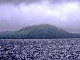
Mount Gharat or Mount Garet (797 m) is the highest peak on the volcanic island of Gaua of the Banks Islands in northern Vanuatu. The peak is located at the centre of the island, is volcanically active and is surrounded by Lake Letas on all sides except southwest.
Mount Gharat on Gaua island
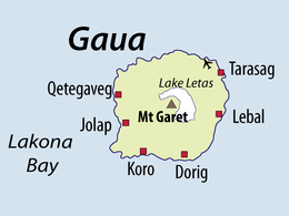
Mt Garet, in the middle of Gaua island
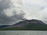
Eruption of Mt Garet in Sept 2010.
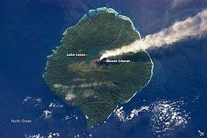
2013 satellite picture of Mt Garet during eruption
References
This article is issued from
Wikipedia.
The text is licensed under Creative Commons - Attribution - Sharealike.
Additional terms may apply for the media files.