Belukha Mountain
| Belukha Mountain | |
|---|---|
 Belukha mountain 2006 | |
| Highest point | |
| Elevation | 4,506 m (14,783 ft) [1] |
| Prominence |
3,343 m (10,968 ft) [1] Ranked 58th |
| Isolation | 668 kilometres (415 mi) |
| Listing | Ultra |
| Coordinates | 49°48′27″N 86°35′24″E / 49.80750°N 86.59000°ECoordinates: 49°48′27″N 86°35′24″E / 49.80750°N 86.59000°E [1] |
| Geography | |
| Location | Altai Republic, Russia |
| Parent range | Altai Mountains |
| Climbing | |
| First ascent | 1914 by B.V. Tronov & M.V. Tronov |
| Easiest route | basic rock/snow climb |
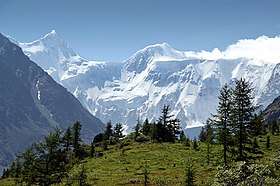
Belukha Mountain (Russian: Белуха, lit. 'whitey'; Altai: Muztau or Üç Sümer), located in the Katun Mountains, is the highest peak of the Altai Mountains in Russia.[2] It is part of the World Heritage Site entitled Golden Mountains of Altai.[3]
Located in the Altai Republic, Belukha is a three-peaked mountain massif that rises along the border of Russia and Kazakhstan, just a few dozen miles north of the point where this border meets with the border of China. There are several small glaciers on the mountain, including Belukha Glacier. Of the two peaks, the eastern peak (4,506 m, 14,784 ft.) is higher than the western peak (4,440 m, 14,567 ft.).
Belukha was first climbed in 1914 by the Tronov brothers. Most ascents of the eastern peak follow the same southern route as that taken in the first ascent. Though the Altai is lower in elevation than other Asian mountain groups, it is very remote, and much time and planning are required for its approach. Russian Pagan and Hindu followers often go on pilgrimages to Mount Belukha, which is considered to be the location of Shambhala both by some Pagans and locals of Altai
Belukha Glacier
In the summer of 2001, a team of scientists traveled to the remote Belukha Glacier to assess the feasibility of extracting ice cores at the site. Research was carried out from 2001 to 2003: both shallow cores and cores to bedrock were extracted and analyzed (Olivier and others, 2003; Fujita and others, 2004). Based on tritium dating techniques, the deeper cores may contain as much as 3–5,000 years of climatic and environmental records. A Swiss-Russian team also studied the glacier. [4]
Access
Since 2008, one is required to apply for a special border zone permit in order to be allowed into the area (if travelling independently without using an agency). Foreigners should apply for the permit to regional FSB border guard office two months before the planned date.[5][6]
See also
References
![]()
- 1 2 3 "The Central Asian Republics Ultra Prominence Page" Listed as "Gora Belukha" on Peaklist.org. Retrieved 2011-11-20.
- ↑ "Mount Belukha". Encyclopædia Britannica. Retrieved 2007-07-31.
- ↑ "Golden Mountains of Altai". UNESCO. Archived from the original on 18 August 2007. Retrieved 2007-07-31.
- ↑ L. DeWayne Cecil; David L. Naftz; Paul F. Schuster; David D. Susong & Jaromy R. Green. "Glaciers of Asia— THE PALEOENVIRONMENTAL RECORD PRESERVED IN MIDDLE LATITUDE, HIGH-MOUNTAIN GLACIERS—AN OVERVIEW OF THE U.S. GEOLOGICAL SURVEY EXPERIENCE IN CENTRAL ASIA AND THE UNITED STATES" (PDF). US Geological Survey (public domain). Retrieved 2012-05-13.
- ↑ http://www.lonelyplanet.com/thorntree/thread.jspa?threadID=1761406&tstart=0
- ↑ http://dontmind.freeshell.org/trekking/altai/#permit
| Wikimedia Commons has media related to Belukha Mountain. |