Monte Sirente
| Monte Sirente | |
|---|---|
 | |
| Highest point | |
| Elevation | 2,347 m (7,700 ft) |
| Coordinates | 42°08′46″N 13°36′40″E / 42.14611°N 13.61111°ECoordinates: 42°08′46″N 13°36′40″E / 42.14611°N 13.61111°E |
| Geography | |
 Monte Sirente Italy | |
| Location | Abruzzo, Italy |
| Parent range | central Apennines |
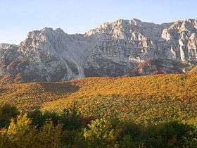
Monte Sirente is a mountain in Abruzzo, central Italy, the highest peak (at 2,349 m) of a small chain extending for c. 13 km from the Altopiano delle Rocche, the Marsica and the Valle Subequana, ending to the Fucino plain. It is part of the Sirente-Velino Regional Park.
The northern side of Sirente is characterized by deep gorges created by glaciers during the last Pleistocene glaciation. The southern side declines in a more milder way towards the Fucino.
Nearby is the Sirente crater.
See also
This article is issued from
Wikipedia.
The text is licensed under Creative Commons - Attribution - Sharealike.
Additional terms may apply for the media files.