Monte Consolino
| Monte Consolino | |
|---|---|
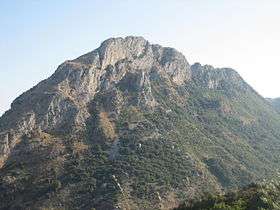 Monte Consolino seen from Bivongi. | |
| Highest point | |
| Elevation | 701 m (2,300 ft) |
| Coordinates | 38°17′06″N 16°16′28″E / 38.28500°N 16.27444°ECoordinates: 38°17′06″N 16°16′28″E / 38.28500°N 16.27444°E |
| Geography | |
 Monte Consolino Calabria, Italy | |
| Parent range | Serre Calabresi |
Monte Consolino is a mountain in the Serre Calabresi range, in the Vallata dello Stilaro of south-western Calabria, in southern Italy. Monte Consolino has an altitude of 701 metres (2,300 ft).
- Geography
At the foot of Monte Consolino feet is the town of Stilo. The town of Pazzano is located nearby between this mountain and Monte Stella. Bivongi is also. It is separated from the Monte Mammicomito by a narrow valley, in which is the town of Pazzano.
- History
On the mountain's top are the stone ruins of the Norman castle built by Roger II of Sicily (1095—1154). Just below, are the ruins of the 'so-called' Byzantine kastrum.
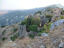
Landscape at the top of Monte Consolino, with the Norman Castle ruins.
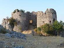
Stone walls of the Norman Castle, built by Roger II of Sicily.
Sources
| Wikimedia Commons has media related to |
- Blanchard, Paul (2007). Southern Italy. London: Somerset Books. ISBN 978-1-905131-18-1.
This article is issued from
Wikipedia.
The text is licensed under Creative Commons - Attribution - Sharealike.
Additional terms may apply for the media files.