Monklands (district)
Coordinates: 55°49′44″N 3°55′19″W / 55.829°N 3.922°W
| Monklands | |
|---|---|
 | |
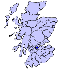 Monklands district within Scotland | |
| History | |
| • Created | 1975 |
| • Abolished | 1996 |
| • Succeeded by | North Lanarkshire |
| Status | District |
| Government | Monklands District Council |
Monklands (Bad nam Manach in Scottish Gaelic) was, between 1975 and 1996, one of nineteen local government districts in the Strathclyde region of Scotland.
The district was formed by the Local Government (Scotland) Act 1973 from:
- The burghs of Coatbridge and Airdrie
- Most of the Lanarkshire landward Ninth District
- The electoral district of Shottskirk from the Lanarkshire landward Seventh District
The district administrative headauarters were based in Coatbridge, the largest conurbation.
Apart from the two burghs, the area included the following settlements:
The district was abolished in 1996 by the Local Government etc. (Scotland) Act 1994. The area of the district was combined with those of Cumbernauld and Kilsyth and Motherwell districts and part of Strathkelvin to become North Lanarkshire unitary council area.
The name of "Monklands" originated in the grant of lands in the area to the monks of the Cistercian Abbey of Newbattle, Midlothian in 1162. From the seventeenth century the area was formed into the two parishes of New Monkland and Old Monkland.[1]
Although the council is gone, the area is often informally referred to as Monklands. Indeed, the local hospital (in Airdrie) is Monklands District General Hospital.
Football matches between the two senior teams in the area, Airdrieonians and Albion Rovers, are often referred to as Monklands Derbies.