Mallarpur
| Mallarpur | |
|---|---|
| Village | |
 Mallarpur Location in West Bengal, India | |
| Coordinates: 24°05′02″N 87°42′36″E / 24.083789°N 87.709934°ECoordinates: 24°05′02″N 87°42′36″E / 24.083789°N 87.709934°E | |
| Country |
|
| State | West Bengal |
| District | Birbhum |
| Population (2011) | |
| • Total | 6,471 |
| Languages | |
| • Official | Bengali, English |
| Time zone | UTC+5:30 (IST) |
| PIN | 731216 (Mallarpur) |
| Telephone code | 03461 |
| Lok Sabha constituency | Bolpur |
| Vidhan Sabha constituency | Mayureswar |
| Website |
birbhum |
Mallarpur is a village in Mayureswar I CD Block in Rampurhat subdivision of Birbhum district in the Indian state of West Bengal.
Etymology
The name Mallarpur had come from Malla kings. Probably, it has some connection with the great Malla king Veer Hambir.
Geography
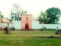
There were four separate villages called Amba, Fatehpur, Bahina and Mallarpur merged to form a small town Mallarpur. As one drives to Mallarpur, off the now busy highway, one will see a grand old ruin dominating the landscape for miles around. This is the Kacheri Baari or the Court House. Built in the late 18th century, this building must have been stunning in its heydays. As one enters through a once grand, but now rusted, metal gate, one comes into the front lawn, about 50 yards long. At the end of it, like a giant spider, sits the Kacheri Baari, a haunted house.[1][2]
There is a "Vanavasi Kalyan Ashram Hostel" near Amba at Mollarpur beside Ramkrishna Ashram.[3]
There is the burial place (samadhi) of Krishnananda Agamavagisha, at Molleswar Shiva temple ground. Krishnananda Agamavagisha was the great tantrik and author of "Brihat Tantrasara" and inventor of Dakshina Kali idol, and guru of Ramprasad Sen.[4]
Police station
There is a police station at Mallarpur.[5]
CD Block HQ
The headquarters of Mayureswar I CD Block are located at Mallarpur.[6]
Demographics
As per the 2011 Census of India, Mallarpur had a total population of 6,471 of which 3,310 (51%) were males and 3,161 (49%) were females. Population below 6 years was 735. The total number of literates in Mallarpur was 4,584 (79.92% of the population over 6 years).[7]
Transport
Mollarpur is an important railway station, having connectivity to several places. Almost all of the local trains passing through Mollarpur, stop at the station and some express train also. One can reach Kolkata in around 3.5 hours. Near about 20 villages are depending on the Mollarpur railway station.
As Panagarh–Morgram Highway passes through the town the road communication is well developed along with the railway communication. NH 14 (old numbering NH 60) is passing through Mallarpur to Suri via Ganpur, Deucha.
Education and Training
Mallarpur High School,Mollarpur Dharani Deben Siksha Niketan and Mollarpur Girl's High School are well known schools at the Mollarpur. Turku Hansda Lopsa Hembrom Mahavidyalaya(THLH College) is situated near by Mallarpur(on NH 14 at Modian Village). There are various private and Government collaborated schools, institutes and organisations which are implementing people education and training.
Culture
People of Mallarpur celebrate all festival with same zeal. The main festivals are Eid, Durga puja, Kalipuja, Chhath, etc. Chhathpuja is celebrated by the Bihari community at Kali Tala in Bahina village and Eid is celebrated by Muslims at Mallarpur Muslim Para.
Poush Sankranti fair is held at Shibpur in the Mayureswar police station area. Shivratri fair is held at Dabuk. Gosaidas fair is held at Dakshingram.
Shivaratri and Gajan are held at Malleswar Shiva temple at gram Mallarpur. Phulkhela (literally play with flowers) is held during Charak Puja at Malleswar. At this phulkhela, bhaktas walk on burning wood.
Dharma pujo fair is held at Ratma on the occasion of Buddha Purnima.
On Shivaratri a grand fair is held at local Nimitala ground beside NH 14.
Ratha Yatra is one of the greatest festivals of Mallarpur.
Healthcare
Mallarpur Rural Hospital at Mallarpur has 30 beds.[8]
 Shiva temple Mollarpur birbhum
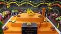
References
- ↑ http://www.m.ndtv.com/video/travel/india-s-most-haunted/inside-a-haunted-house-called-kacheri-badi-203739
- ↑ NDTV Good Times (1 July 2011). "Inside a haunted house called Kacheri Badi" – via YouTube.
- ↑ "EXCLUSIVE: Inside a Hindutva hostel: how RSS is rewiring the tribal mind".
- ↑ "Krishnananda Agamavagisha".
- ↑ "Birbhum Police". Police Stations. West Bengal Police. Retrieved 30 January 2018.
- ↑ "District Census Handbook: Birbhum, Series 20, Part XII B" (PDF). Map of Birbhum with CD Block HQs and Police Stations (on the fourth page). Directorate of Census Operations, West Bengal, 2011. Retrieved 1 February 2018.
- ↑ "2011 Census – Primary Census Abstract Data Tables". West Bengal – District-wise. Registrar General and Census Commissioner, India. Retrieved 1 February 2018.
- ↑ "Health & Family Welfare Department" (PDF). Health Statistics – Rural Hospitals. Government of West Bengal. Retrieved 26 January 2018.
Cities, towns and locations in Birbhum district | |||||||
|---|---|---|---|---|---|---|---|
| Cities, municipal and census towns |
| ||||||
| Locations other than cities and towns |
| ||||||
| See also |
| ||||||