Serra de Llaberia
| Serra de Llaberia | |
|---|---|
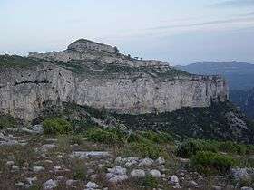 View of Mont-redon's massive karstic cliffs | |
| Highest point | |
| Elevation | 918.3 m (3,013 ft) |
| Coordinates | 41°5′23″N 0°51′54″E / 41.08972°N 0.86500°ECoordinates: 41°5′23″N 0°51′54″E / 41.08972°N 0.86500°E |
| Geography | |
 Serra de Llaberia Catalonia, Spain | |
| Location | Baix Camp & Ribera d'Ebre, (Catalonia) |
| Parent range | Catalan Pre-Coastal Range |
| Geology | |
| Mountain type | Karstic |
| Climbing | |
| First ascent | Unknown |
| Easiest route | From Fatges or Tivissa |
Serra de Llaberia is a mountain chain in Catalonia, Spain located between the Prades and the Tivissa-Vandellòs Mountains.
It is part of the Catalan Pre-Coastal Range. The main peaks are Mola de Llaberia (918.3 m), La Miranda (918 m) and Mont-redon (864 m).[1]
This mountain range is named after Llaberia village, now a ghost town within the Tivissa municipal term. The Serra de Montalt mountain range is a subrange of the main Llaberia range.
See also
References
External links
| Wikimedia Commons has media related to Serra de Llaberia. |
This article is issued from
Wikipedia.
The text is licensed under Creative Commons - Attribution - Sharealike.
Additional terms may apply for the media files.