Mohr County
| Mohr County شهرستان مهر | |
|---|---|
| County | |
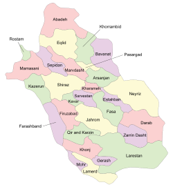 Location in Fars Province | |
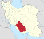
 Location of Fars Province in Iran | |
| Coordinates: 27°47′N 52°35′E / 27.783°N 52.583°ECoordinates: 27°47′N 52°35′E / 27.783°N 52.583°E | |
| Country |
|
| Province | Fars |
| Capital | Mohr |
| Bakhsh (Districts) | Central District, Galleh Dar District, Varavi District, Asir District |
| Population (2006) | |
| • Total | 54,094 |
| Time zone | UTC+3:30 (IRST) |
| • Summer (DST) | UTC+4:30 (IRDT) |
| Mohr County can be found at GEOnet Names Server, at this link, by opening the Advanced Search box, entering "9206575" in the "Unique Feature Id" form, and clicking on "Search Database". | |
Mohr County (Persian: شهرستان مهر) is a county in Fars Province in Iran. The capital of the county is Mohr. Its main industries are based on its rich gas sources. Tabnak, Homa, Shanol, Varavi and Parsian refinary are important Gas Zones in this region. It has a dry hot climate. At the 2006 census, the county's population was 54,094, in 10,999 families.[1] The county is subdivided into four districts: the Central District, Galleh Dar District, Varavi District, and Asir District. The county has five cities: Mohr, Varavi, Asir, Galleh Dar & Khuzi.
References
- ↑ "Census of the Islamic Republic of Iran, 1385 (2006)". Islamic Republic of Iran. Archived from the original (Excel) on 2011-11-11.
- اطلس گیتاشناسی استانهای ایران [Atlas Gitashenasi Ostanhai Iran] (Gitashenasi Province Atlas of Iran)
| Capital | |||||||||||||||||||||||||||||||||||||||||
|---|---|---|---|---|---|---|---|---|---|---|---|---|---|---|---|---|---|---|---|---|---|---|---|---|---|---|---|---|---|---|---|---|---|---|---|---|---|---|---|---|---|
| Districts |
| ||||||||||||||||||||||||||||||||||||||||
This article is issued from
Wikipedia.
The text is licensed under Creative Commons - Attribution - Sharealike.
Additional terms may apply for the media files.