Mittelweg
| Mittelweg | |
|---|---|
| Trailheads |
|
The Mittelweg ("Middle Way") is a north-south long-distance path which runs through the Black Forest from Pforzheim to Waldshut. It is about 230 kilometres long and was established in 1903. Since then it has been maintained and sponsored by the Black Forest Club. Its waymark is a red diamond with a white bar on a white background.
Description
From Pforzheim the path initially runs over the plateau between the Enz and Nagold valleys. Passing the raised bogs of the Northern Black Forest it goes to Freudenstadt and continues through the Central Black Forest via the Fohrenbühl and St. Georgen to the Hochfirst. In the Southern Black Forest the ‘’Mittelweg’’ passes through the valleys of the Schwarza and Schlücht (western branch) or Mettma (eastern branch) and reaches the High Rhine at Waldshut.
Route
| No. | Start of stage | End of stage | Route (km) |
Walking time (h) |
|---|---|---|---|---|
| 1. | Pforzheim | Bad Wildbad | 23 | 5.5 |
| 2. | Bad Wildbad | Besenfeld | 31 | 8 |
| 3. | Besenfeld | Oberzwieselberg | 26 | 6.5 |
| 4. | Oberzwieselberg | Schiltach | 25 | 6 |
| 5. | Schiltach | St. Georgen | 30.5 | 7.5 |
| 6. | St. Georgen | Kalte Herberge | 25.5 | 6.5 |
| 7. | Kalte Herberge | Lenzkirch | 25.5 | 6.5 |
| 8.A | Lenzkirch | Häusern | 20 | 5 |
| 9.A | Häusern | Waldshut | 23 | 5.5 |
| 8.B | Lenzkirch | Rothaus | 13 | 3.5 |
| 9.B | Rothaus | Waldshut | 29 | 7 |
Common stages: Pforzheim – Lenzkirch
1st Stage: Pforzheim – Bad Wildbad
- Distance: 23 km
- Journey time: c. 5.5 hours
| No. | Place/Attraction | Route (km) |
Height (m above NHN) |
Further information |
|---|---|---|---|---|
| 1. | Pforzheim-Kupferhammer | 0 | 254 | Start of the Mittelweg, Ostweg (to Schaffhausen) and Westweg (to Basel) |
| 2. | Dillweißenstein | 2.5 | 285 | District of Pforzheim |
| 3. | Büchenbronn | 2.5 | 465 | District of Pforzheim |
| 4. | Hermannsee | 1 | 460 | |
| 5. | Büchenbronner Height | 1.5 | 609 | Büchenbronn Viewing Tower |
| 6. | Engelsbrand | 1.5 | 547 | |
| 7. | Langenbrand | 3.5 | 672 | Village in the municipality of Schömberg |
| 8. | Charlottenhöhe | 4 | 684 | Vocational promotion centre building |
| 9. | Calmbach | 2.5 | 399 | Village in the municipality of Bad Wildbad |
| 10. | Bad Wildbad | 4 | 426 |
2nd Stage: Bad Wildbad – Besenfeld
- Distance: 31 km
- Journey time: c. 8 hours
| No. | Place/Attraction | Route (km) |
Height (m above NHN) |
Further information |
|---|---|---|---|---|
| 1. | Bad Wildbad | 0 | 426 | |
| 2. | Fünf Bäume | 4 | 784 | |
| 3. | Grünhütte | 3.5 | 837 | Ausflugslokal |
| 4. | Weißensteinhütte | 1.5 | 883 | Branch to the Wildsee |
| 5. | Kaltenbronn | 4.6 | 869 | Village in the municipality of Gernsbach, info centre |
| 6. | Hohlohsee | 1.2 | 980 | Hochmoorsee |
| 7. | Hohloh Tower | 0.7 | 984 | Viewing tower, refuge hut |
| 8. | Prinzenhütte | 1.3 | 954 | Refuge hut |
| 9. | Toter Mann | 4.7 | 915 | |
| 10. | Schramberg | 2.3 | 906 | Log cabin Memorial to Murg Navigation Forest Inspector, Arnsperger The forest in the area belonged in the 18th century to the Murg Navigation, which sent wood from the Black Forest to Holland. |
| 11. | Neuhaus-Hütte | 3.7 | 888 | |
| 12. | Besenfeld | 3.5 | 782 | Village in the municipality of Seewald |
3rd Stage: Besenfeld – Oberzwieselberg
- Distance: 26 km
- Journey time: c. 6.5 hours
| No. | Place/Attraction | Route (km) |
Height (m above NHN) |
Further information |
|---|---|---|---|---|
| 1. | Besenfeld | 0 | 782 | |
| 2. | Ruine Königswart | 3.5 | 790 | Memorial site for Count Palatine Rudolf of Tübingen from the year 1209 |
| 3. | Igelsberger Hardt | 4.5 | 790 | |
| 4. | Frutenhofer Wald | 4.5 | 700 | |
| 5. | Buschige Fichte | 4 | 780 | |
| 6. | Freudenstadt | 4.5 | 740 | |
| 7. | Oberzwieselberg | 5 | 841 | District of Freudenstadt |
4th Stage: Oberzwieselberg – Schiltach
- Distance: 25 km
- Journey time: c. 6 hours
| No. | Place/Attraction | Route (km) |
Height (m above NHN) |
Further information |
|---|---|---|---|---|
| 1. | Oberzwieselberg | 0 | 841 | |
| 2. | Schmiedsberger Platz | 8 | 773 | Crosses the Little Hansjakob Way; refuge hut |
| 3. | Tor | 3 | 705 | Crosses the Gengenbach–Alpirsbach Trail |
| 4. | Bocksecke | 1 | 810 | |
| 5. | Emil Hut (Emilshütte) | 1.5 | 800 | |
| 6. | Salzlecke | 1 | 760 | Refuge hut |
| 7. | Teisenkopf | 5 | 764 | Viewing tower |
| 8. | Kuhberg-Mattenweiher | 1.5 | 638 | |
| 9. | Schiltach | 4 | 325 |
5th Stage: Schiltach – St. Georgen
- Distance: 30.5 km
- Journey time: c. 7.5 hours
| No. | Place/Attraction | Route (km) |
Height (m above NHN) |
Further information |
|---|---|---|---|---|
| 1. | Schiltach | 0 | 325 | |
| 2. | Dornacker | 3.5 | 660 | |
| 3. | Bauernhof Grusenloch | 2.5 | 770 | |
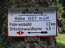
| 4. | Mooswaldkopf | 4 | 879 | SV Wanderheim Fohrenbühl observation tower (planned by Paul Bonatz) |
| 5. | Fohrenbühl | 1 | 787 | Village in the municipality of Lauterbach and Hornberg (the boundary runs through the settlement.) |
| 6. | Falkenhöhe | 4 | 858 | |
| 7. | Benzebene | 3.5 | 896 | |
| 8. | Windkapf | 1.5 | 928 | |
| 9. | Lindenbüble | 3 | 885 | SV-Wanderheim |
| 10. | Gasthof Staude | 2 | 889 | Crosses the Rottweil–Lahr Trail |
| 11. | Hochwälder Height | 3 | 966 | |
| 12. | St. Georgen | 3 | 862 |
6th Stage: St. Georgen – Kalte Herberge
- Distance: 25.5 km
- Journey time: c. 6.5 hours
| No. | Place/Attraction | Route (km) |
Height (m above NHN) |
Further information |
|---|---|---|---|---|
| 1. | St. Georgen | 0 | 862 | |
| 2. | Kreuzweg | 4 | 951 | |
| 3. | Kesselberg Fuchsfalle | 4 | 1.010 | |
| 4. | Triberg Gallows (Triberger Galgen) | 1 | 1.020 | |
| 5. | Stöcklewald Tower | 1 | 1.069 | SV Wanderheim observation tower |
| 6. | Fürsatz | 3 | 1.036 | |
| 7. | Furtwangen | 5 | 872 | Crosses the Black Forest–Kaiserstuhl–Rhine Trail |
| 8. | Hohles Bildstöckle | 5 | 1.060 | |
| 9. | Kalte Herberge | 2 | 1.029 | Gasthof |
7th Stage: Kalte Herberge – Lenzkirch
- Distance: 25.5 km
- Journey time: c. 6.5 hours
| No. | Place/Attraction | Route (km) |
Height (m above NHN) |
Further information |
|---|---|---|---|---|
| 1. | Kalte Herberge | 0 | 1.029 | |
| 2. | Hochberg | 3 | 1.130 | Gasthof Engel |
| 3. | Margrutt | 2 | 1.049 | |
| 4. | Ferdinandshöhe | 4.5 | 1.031 | |
| 5. | Am Wiedenkreuz | 3 | 1.010 | |
| 6. | Neustadt | 3.5 | 828 | |
| 7. | Saiger Kreuz | 3 | 1.028 | |
| 8. | Hochfirst | 1 | 1.190 | Crosses the Freiburg–Lake Constance Trail SV Wanderheim observation tower |
| 9. | Hierabrunnen | 2.5 | 1.114 | Refuge hut |
| 10. | Lenzkirch | 3 | 808 | Crosses the Schluchtensteig |
Western branch: Lenzkirch – Waldshut
8th Stage: Lenzkirch – Häusern
- Distance: 20 km
- Journey time: c. 5 hours
| No. | Place/Attraction | Route (km) |
Height (m above NHN) |
Further information |
|---|---|---|---|---|
| 1. | Lenzkirch | 0 | 808 | |
| 2. | Brisgowenkapelle | 4.5 | 1.075 | |
| 3. | Schluchsee | 3.5 | 951 | |
| 4. | Seebrugg railway station | 3 | 932 | |
| 5. | Schluchsee Dam | 1 | 931 | |
| 6. | Eisenbreche | 1.5 | 914 | |
| 7. | Blasiwald-Althütte | 2.5 | 1.088 | Village in the municipality of Schluchsee Crosses the Schluchtensteig |
| 8. | Häusern | 4 | 891 |
9th Stage: Häusern – Waldshut
- Distance: 23 km
- Journey time: c. 5.5 hours
| No. | Place/Attraction | Route (km) |
Height (m above NHN) |
Further information |
|---|---|---|---|---|
| 1. | Häusern | 0 | 891 | |
| 2. | Höchenschwand | 3 | 1.010 | |
| 3. | Kreuzstein | 1 | 968 | Forest car park |
| 4. | Fohrenbachmühle | 7 | 600 | |
| 5. | Nöggenschwiel | 1.5 | 719 | Village in the municipality of Weilheim |
| 6. | Heubach | 2 | 737 | |
| 7. | Indlekofen | 3.5 | 540 | District of Waldshut-Tiengen |
| 8. | Waldshut | 5 | 343 |
Eastern branch: Lenzkirch – Waldshut
8th Stage: Lenzkirch – Rothaus
- Distance: 13 km
- Journey time: c. 3.5 hours
| No. | Place/Attraction | Route (km) |
Height (m above NHN) |
Further information |
|---|---|---|---|---|
| 1. | Lenzkirch | 0 | 808 | |
| 2. | Kinderheim Dresselbach | 7 | 1.064 | |
| 3. | Dürrenbühl | 4 | 1.028 | St. Cyriakus pilgrimage church |
| 4. | Rothaus | 2 | 971 | Village in the municipality of Grafenhausen |
9th Stage: Rothaus – Waldshut
- Distance: 30 km
- Journey time: c. 7 hours
| No. | Place/Attraction | Route (km) |
Height (m above NHN) |
Further information |
|---|---|---|---|---|
| 1. | Rothaus | 0 | 971 | |
| 2. | Schaffhauser Säge | 3 | 800 | |
| 3. | Klausenmühle | 3 | 1.090 | |
| 4. | Buggenrieder Mühle | 3 | 730 | |
| 5. | Lochmühle | 4.5 | 608 | |
| 6. | Mettmamündung | 2.5 | 520 | Mouth of the Mettma on the Mettma Reservoir |
| 7. | Witznau | 4 | 436 | |
| 8. | Gutenburg | 4.5 | 390 | District of Waldshut-Tiengen |
| 9. | Gurtweil | 2.5 | 373 | District of Waldshut-Tiengen |
| 10. | Waldshut | 3 | 342 |
External links
- Black Forest Hiking Service: web service of the Black Forest Club enabling visualisation of the Black Forest trails on Google Maps with various overlays (trail network, signs, accommodation, …)
| Ridgeways (north-south trails): | ||
|---|---|---|
| East-west trails: | ||
| Perimeter trails: |
| |
| Other Black Forest trails: |
| |