Mission Hills, Los Angeles
| Mission Hills | |
|---|---|
| Neighborhood of Los Angeles | |
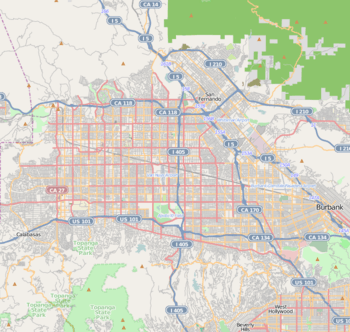 Mission Hills Location within Los Angeles/San Fernando Valley 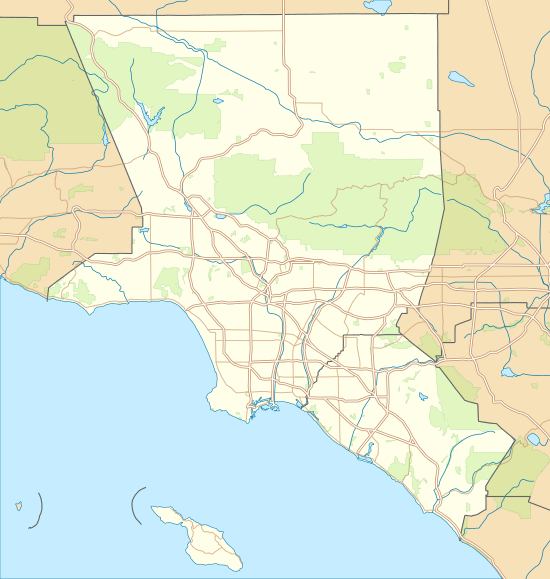 Mission Hills Mission Hills (the Los Angeles metropolitan area) | |
| Coordinates: 34°15′26″N 118°28′02″W / 34.25722°N 118.46722°W | |
| Country | United States |
| State | California |
| County | Los Angeles |
| City | Los Angeles |
| Named for | Mission San Fernando Rey de España |
| Elevation | 913 ft (278 m) |
| Population (2000)[1] | |
| • Total | 15,056 |
| Time zone | UTC−8 (PST) |
| • Summer (DST) | UTC−7 (PDT) |
| ZIP Code | 91345 |
| Area code(s) | 747 and 818 |
Mission Hills is an urban residential community of the San Fernando Valley, within the city of Los Angeles, California.
It is near the northern junction of the Golden State Freeway (I-5) and the San Diego Freeway (I-405). The Ronald Reagan Freeway (SR-118) halves the community. Mission Hills is at the northern end of the long Sepulveda Boulevard. Other main thoroughfares are San Fernando Mission Boulevard, Woodman Avenue, and Rinaldi, Brand, Chatsworth, Devonshire, and Lassen Streets. The boundaries are roughly Sepulveda Blvd and Interstate 405 to the west, Interstate 5 to the north and east, Van Nuys Boulevard to the southeast, and Lassen Street to the south. The Granada Hills community lies to the west, Sylmar to the north, the city of San Fernando to the northeast, Pacoima to the east, Arleta to the southeast, and Panorama City to the south.
The community is named for the nearby Spanish Mission San Fernando Rey de España (1784). It includes the Andrés Pico Adobe, the second oldest residence still standing in Los Angeles. The San Fernando Mission Cemetery, located a short distance away, is one of the oldest active cemeteries within the San Fernando Valley.
Demographics
The 2010 U.S. census counted 18,496 residents in the area's 91345 ZIP Code. The median age was 36.3, and the median yearly household income at that time was $62,426.[2]
In 2009, the Los Angeles Times's "Mapping L.A." project supplied the following numbers for the community of Mission Hills. Population: 18,237; median household income: $75,675.[3]
Government and infrastructure
The Los Angeles County Department of Health Services operates the Pacoima Health Center in Pacoima, serving Mission Hills.[4]
Education
Residents are zoned to schools in the Los Angeles Unified School District.
Medical centers
Providence Holy Cross Medical Center is located within the community. Facey Medical Group is located within the community. A newly opened Kaiser Permanente also lies in the community [5]
Government and infrastructure
The United States Postal Service operates the Mission Hills Post Office at 15305 Devonshire Street and the Mission City Post Office at 10919 Sepulveda Boulevard.[6][7]
In May 2005, the Los Angeles Police Mission Area was established as the 19th station built in the City of Los Angeles. This police station serves the communities of Mission Hills, Sylmar, North Hills, Arleta, and Panorama City.
Economy
Tourism
Tourists visit the Mission San Fernando Rey de España, a historical mission. The Andres Pico Adobe is the second oldest Adobe home in the City of Los Angeles[8]
Notable natives

People who were born in Mission Hills, Los Angeles:
- Ryan Braun (major league baseball All Star and MVP outfielder)
- Jessica Cosby (Olympic athlete; track and field)
- Michael Kuluva (fashion designer)
- Kevin Lenik (professional baseball player)
- George Lopez (comedian)
- Scott McAfee (actor)
See also
References
- ↑ "Los Angeles Almanac: City of Los Angeles Population by Community & Race 2000 Census". Archived from the original on January 11, 2010. Retrieved November 28, 2008.
- ↑ Archived 2014-12-10 at the Wayback Machine. "Community Facts" American FactFinder, United States Census Bureau
- ↑ "Mission Hills" entry on the Los Angeles Times "Mapping L.A." website
- ↑ "Pacoima Health Center." Los Angeles County Department of Health Services. Retrieved on March 17, 2010.
- ↑ http://www.facey.com/search-location.php?txtloc=6
- ↑ "Post Office Location – MISSION HILLS." United States Postal Service. Retrieved on December 6, 2008.
- ↑ "Post Office Location – MISSION CITY." United States Postal Service. Retrieved on December 6, 2008.
- ↑ http://www.laparks.org/dos/historic/andres.htm
Places adjacent to Mission Hills, Los Angeles | ||||||||||
|---|---|---|---|---|---|---|---|---|---|---|
| ||||||||||
| By topic |  | |
|---|---|---|
| Government | ||
| Districts and neighborhoods |
|  |
|---|---|---|
| Points of interest | ||
| Neighboring cities and communities | ||
Coordinates: 34°15′26″N 118°28′02″W / 34.257222°N 118.467222°W