Milejovice
| Milejovice | |
|---|---|
| Municipality | |
 Milejovice | |
| Coordinates: 49°11′12″N 13°56′12″E / 49.18667°N 13.93667°ECoordinates: 49°11′12″N 13°56′12″E / 49.18667°N 13.93667°E | |
| Country |
|
| Region | South Bohemian |
| District | Strakonice |
| Area | |
| • Total | 6.22 km2 (2.40 sq mi) |
| Elevation | 530 m (1,740 ft) |
| Population (2006) | |
| • Total | 62 |
| • Density | 10.0/km2 (26/sq mi) |
| Postal code | 387 01 |
| Website | http://www.milejovice.cz |

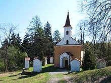
Chapel in the village
Milejovice is a village and municipality (obec) in Strakonice District in the South Bohemian Region of the Czech Republic.
The municipality covers an area of 6.22 square kilometres (2.40 sq mi), and has a population of 62 (as at 3 July 2006).
Milejovice lies approximately 9 kilometres (6 mi) south of Strakonice, 46 km (29 mi) north-west of České Budějovice, and 106 km (66 mi) south of Prague.
Sights
- Virgin Mary chapel
- Chapel at the Dobrá voda well
- Stations of the Cross
References
Stations of the Cross and the chapel at Dobrá voda
| Wikimedia Commons has media related to Milejovice. |
| Wikimedia Commons has media related to Dobrá voda. |
This article is issued from
Wikipedia.
The text is licensed under Creative Commons - Attribution - Sharealike.
Additional terms may apply for the media files.