Middle Brook (Raritan River tributary)
Middle Brook is a tributary of the Raritan River in Somerset, New Jersey, in the United States. The stream can be referred to as Rha-weigh-weiros, a Native American name meaning "running from a deep hole", on early maps of the area.[1]
Washington Valley
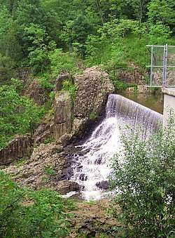
The Middle Brook's western and eastern branches drain the valley, now known as Washington Valley, between the first and second Watchung Mountain ridges in Bridgewater Township and the western part of Warren Township.[2] The two branches unite in the Bound Brook Gap and the Middle Brook runs southward where it enters the Raritan in Bound Brook. The total drainage area is 17.2 square miles (45 km2).[3] The Western Branch is followed by the Middle Brook Trail, a public hiking trail.[4][5] In Washington Valley Park, the brook forms an artificial lake, the Washington Valley Reservoir. The smaller Eastern Branch is also dammed and then cascades over the Buttermilk Falls in Washington Valley Park.
Flood control
The Middle Brook section in Bound Brook is being regulated as part of the Green Brook Flood Control Project in an attempt to spare Bound Brook flooding from backwater from the Raritan that can enter the terminal section of the Middle Brook.
See also
References
- ↑ The story of an old farm: or, Life in New Jersey in the eighteenth ..., Part 1, p. 169; By Andrew D. Mellick
- ↑ Hunter, Richard W.; Ian, C. G. Burrow (2005). "The Historical Geography and Archaeology of the Revolutionary War in New Jersey". In Mitnick, Barbara J. New Jersey in the American Revolution. Rutgers University Press. p. 176. ISBN 0-8135-3602-2.
- ↑ "National Water Information System: USGS 01403200, Middle Brook at Bound Brook, NJ". United States Geological Survey.
- ↑ Middle Brook Trail
- ↑ Bridgewater Township. "Welcome to the middle brook trail". Archived from the original on 2009-01-23.
External links
- "Washington Valley". Geographic Names Information System. United States Geological Survey. – River basin
Coordinates: 40°33′55″N 74°33′03″W / 40.565233°N 74.550811°W