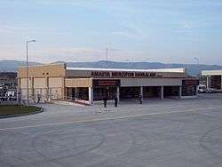
Amasya Merzifon Airport
| Amasya Merzifon Airport Amasya Merzifon Havalimanı | |||||||||||
|---|---|---|---|---|---|---|---|---|---|---|---|
 | |||||||||||
| Summary | |||||||||||
| Airport type | Public / Military | ||||||||||
| Operator | General Directorate of State Airports Authority | ||||||||||
| Location | Merzifon, Amasya, Turkey | ||||||||||
| Elevation AMSL | 1,758 ft / 536 m | ||||||||||
| Coordinates | 40°49′45″N 035°31′19″E / 40.82917°N 35.52194°ECoordinates: 40°49′45″N 035°31′19″E / 40.82917°N 35.52194°E | ||||||||||
| Website | http://merzifon.dhmi.gov.tr/ | ||||||||||
| Map | |||||||||||
 MZH Location of airport in Turkey | |||||||||||
| Runways | |||||||||||
| |||||||||||
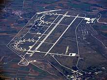
Aeriak view of the airport.
Merzifon Airport or Amasya Merzifon Airport (IATA: MZH, ICAO: LTAP) is a military airport located in the city of Merzifon in the Amasya Province of Turkey.
Airlines and destinations
| Airlines | Destinations |
|---|---|
| Pegasus Airlines | Istanbul–Sabiha Gökçen |
| Turkish Airlines | Istanbul–Atatürk |
Military usage
Merzifon is the 5th Air Wing (Ana Jet Üs or AJÜ) of the 2nd Air Force Command (Hava Kuvvet Komutanligi) of the Turkish Air Force (Türk Hava Kuvvetleri). Other wings of this command are located in Malatya/Erhaç (LTAT), Diyarbakır (LTCC) and İncirlik (LTAG).[3]
References
- ↑ Airport information for LTAP at World Aero Data. Data current as of October 2006.Source: DAFIF.
- ↑ Airport information for LTAP at Great Circle Mapper. Source: DAFIF (effective October 2006).
- ↑ scramble.nl - Turkish Air Force Archived 2010-10-01 at the Wayback Machine.
External links
This article is issued from
Wikipedia.
The text is licensed under Creative Commons - Attribution - Sharealike.
Additional terms may apply for the media files.