Mull Hill
| Mull Hill | |
|---|---|
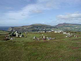 Mull Circle on top of Mull Hill, looking towards Port Erin | |
| Highest point | |
| Elevation | 169 m (554 ft) |
| Prominence | c. 154 m |
| Listing | Marilyn |
| Geography | |
| Location | Isle of Man |
| OS grid | SC189676 |
| Topo map | OS Landranger 95 |
Mull Hill (Manx: Cronk Meayll; also called Meayll Hill or The Mull) is a small hill at the southern end of the Isle of Man, just outside the village of Cregneash. It is the site of a chambered cairn called Mull Circle or Meayll Circle. Near the summit of the hill also lie the remains of a World War II Chain Home Low RDF station.
Mull Hill Stone Circle is a unique archaeological monument. It consists of 12 burial chambers placed in a ring, with 6 entrance passages leading into each pair of chambers. Sherds of ornate pottery, charred bones, flint tools and white quartz pebbles have been found in burial chambers. This archaeological monument was built around 3500 BC; it is a site of legends with diverse stories about haunting.
The word Meayll means "bald" in Manx Gaelic.
Meayll Circle
- The Stone Circle and artifacts
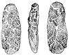 Three views of an adze, from Meayll Hill, Isle of Man
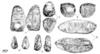 Worked flints found on Meayll Hill, Isle of Man
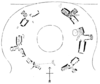 Plan of the Meayll Stone Circle, Isle of Man
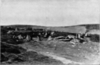 Meayll Stone Circle from the east, Isle of Man
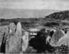 Meayll Stone Circle, excavated cist, Isle of Man
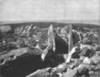 Meayll Stone Circle, excavated cist (another view), Isle of Man
References
Bibliography
- Kermode, Philip Moore Callow (June 1894), Allen]], J. Romilly, ed., "The illustrated archaeologist: a quarterly journal, devoted to the study of the antiquities of Great Britain; the development of the arts and industries of man in past ages; and the survivals of ancient usages and appliances in the present", The Illustrated Archaeologist, London: Charles J. Clark (published 1894), I: 1–8 Check date values in:
|year= / |date= mismatch(help);|contribution=ignored (help) - Kermode, Philip Moore Callow; Herdman, W. A. (1904), Illustrated Notes on Manks Antiquities, Liverpool
Citations
External links
| Wikimedia Commons has media related to Meayll Hill. |