McMurdo Dry Valleys
Coordinates: 77°28′S 162°31′E / 77.467°S 162.517°E
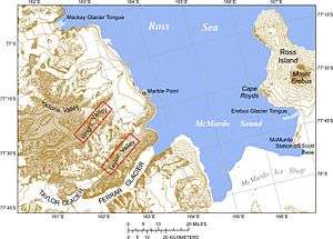
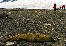
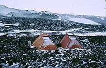
The McMurdo Dry Valleys are a row of snow-free valleys in Antarctica located within Victoria Land west of McMurdo Sound.[1] The Dry Valleys experience extremely low humidity and surrounding mountains prevent the flow of ice from nearby glaciers. The rocks here are granites and gneisses, and glacial tills dot this bedrock landscape, with loose gravel covering the ground.
The region is one of the world's most extreme deserts, and includes many features including Lake Vida, a saline lake, and the Onyx River, a meltwater stream and Antarctica's longest river. Although no living organisms have been found in the permafrost here, endolithic photosynthetic bacteria have been found living in the relatively moist interior of rocks and anaerobic bacteria, with a metabolism based on iron and sulfur, live under the Taylor Glacier.
Climate
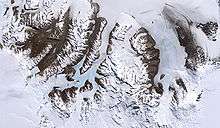
The Dry Valleys are so named because of their extremely low humidity and their lack of snow or ice cover. They are also dry because, in this location, the mountains are sufficiently high that they block seaward flowing ice from the East Antarctic ice sheet from reaching the Ross Sea. At 4,800 square kilometres (1,900 sq mi), the valleys constitute around 0.03% of the continent, and form the largest ice-free region in Antarctica. The valley floors are covered with loose gravel, in which ice wedge polygonal patterned ground may be observed.[2]
The unique conditions in the Dry Valleys are caused, in part, by katabatic winds; these occur when cold, dense air is pulled downhill by the force of gravity. The winds can reach speeds of 320 kilometres per hour (200 mph), heating as they descend, and evaporating all water, ice and snow.[3]
Geology
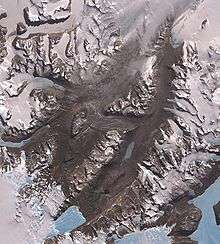
The valleys cut through the Beacon Supergroup, as well as older granites and gneisses of the Ross Orogeny. Deposited directly from ice, tills dot this bedrock landscape. These are relatively thin and patchy, and differ markedly from the extensive, mud-rich tills of the Laurentide ice sheet in the Northern Hemisphere. One reason for the difference is that most of the tills in the Dry Valleys were deposited from cold-based ice (ice with basal temperatures below 0 °C (32 °F)), whereas the Laurentide ice sheet was largely wet-based, with significant melting at the base and at the glacier surface.
Life
Endolithic photosynthetic bacteria have been found living in the Dry Valleys, sheltered from the dry air in the relatively moist interior of rocks. Summer meltwater from the glaciers provides the primary source of soil nutrients.[4] Scientists consider the Dry Valleys perhaps the closest of any terrestrial environment to the planet Mars, and thus an important source of insights into possible extraterrestrial life.
Anaerobic bacteria whose metabolism is based on iron and sulfur live in sub-freezing temperatures under the Taylor Glacier. It was previously thought that the algae was staining red the ice emerging at Blood Falls but it is now known that the staining is caused by high levels of iron oxide.[5][6]
Canadian and American researchers conducted a field expedition in 2013 to University Valley in order to examine the microbial population and to test a drill designed for sampling on Mars in the permafrost of the driest parts of the valleys, the areas most analogous to the Martian surface. They found no living organisms in the permafrost, the first location on the planet visited by humans with no active microbial life.[7]
Part of the Valleys was designated an environmentally protected area in 2004.
Major geographic features
Valleys
- Alatna Valley (sometimes incorrectly spelled Atlanta Valley[8]) is the northernmost, north of Benson Glacier.
From north to south, the three main valleys are
- Victoria Valley (between St. Johns Range in the north and Olympus Range in the south)
- Wright Valley (between Olympus Range in the north and Asgard Range in the south)
- Taylor Valley (between Asgard Range in the north and Kukri Hills in the south)
West of Victoria Valley are, from north to south,
Stretching south from Balham Valley are, from west to east:
West of Taylor Valley is
- Pearse Valley (sometimes incorrectly spelled Pearce Valley).
Further south, between Royal Society Range in the west and the west coast of McMurdo Sound at the lobe of Koettlitz Glacier are, from north to south:
Lakes
Some of the lakes of the Dry Valleys rank among the world's most saline lakes, with a higher salinity than Lake Assal (Djibouti) or the Dead Sea. The most saline of all is small Don Juan Pond.
- Lake Vida (Victoria Valley)
- Lake Vanda (Wright Valley)
- Lake Brownworth (Wright Valley) (freshwater)
- Don Juan Pond (Wright Valley)
- Lake Fryxell (Taylor Valley)
- Lake Hoare (Taylor Valley)
- Lake Chad (Taylor Valley)
- Parera Pond (Taylor Valley) (freshwater)
- Lake Bonney (Taylor Valley)
- Lake Joyce (Pearse Valley)
- Lake Garwood (Garwood Valley)
- Lake Miers (Miers Valley)
Rivers
- Kite Stream (Victoria Valley)
- Onyx River (Wright Valley)
- Vincent Creek (Taylor Valley)
- Crescent Stream (Taylor Valley)
- Harnish Creek (Taylor Valley)
- Huey Creek (Taylor Valley)
- Lost Seal Stream (Taylor Valley)
See also
References
- ↑ Rejcek, Peter (29 November 2007). "In the cold of the night". The Antarctic Sun. Retrieved 2008-01-13.
- ↑ Bockheim, J. G. (2002). "Landform and Soil Development in the McMurdo Dry Valleys, Antarctica: A Regional Synthesis". Arctic, Antarctic, and Alpine Research. 34 (3): 308–317. doi:10.2307/1552489. JSTOR 1552489. (Subscription required (help)).
- ↑ Lloyd, John; Mitchinson, John (2006). The Book of General Ignorance. Faber & Faber.
- ↑ Barrett, J. E.; Virginia, R. A.; Lyons, W. B.; McKnight, D. M.; Priscu, J. C.; Doran, P. T.; Fountain, A. G.; Wall, D. H.; Moorhead, D. L. (2007-03-01). "Biogeochemical stoichiometry of Antarctic Dry Valley ecosystems". Journal of Geophysical Research: Biogeosciences. 112 (G1): G01010. doi:10.1029/2005JG000141. ISSN 2156-2202.
- ↑ Timmer, John (16 April 2009). "Ancient, frozen ecosystem produces blood-red ice flows". Ars Technica. Retrieved 17 April 2009.
- ↑ Mikucki, Jill A.; Pearson, Ann; Johnston, David T.; Turchyn, Alexandra V.; Farquhar, James; Schrag, Daniel P.; Anbar, Ariel D.; Priscu, John C.; Lee, Peter A. (17 April 2009). "A Contemporary Microbially Maintained Subglacial Ferrous "Ocean"". Science. 324 (5925): 397–400. doi:10.1126/science.1167350. PMID 19372431. Retrieved 2009-04-21. (Subscription required (help)).
- ↑ Goordial, Jacqueline; Davila, Alfonso; Lacelle, Denis; Pollard, Wayne; Marinova, Margarita M.; Greer, Charles W.; DiRuggiero, Jocelyn; McKay, Christopher P.; Whyte, Lyle G. (19 January 2016). "Nearing the cold-arid limits of microbial life in permafrost of an upper dry valley, Antarctica". The ISME Journal. Retrieved 24 January 2016.
- ↑ "Map of the McMurdo Dry Valleys Area" (PDF). Antarctica New Zealand. Archived from the original (pdf) on 2009-03-27.
External links
| Wikimedia Commons has media related to McMurdo Dry Valleys. |
- Special Report: The McMurdo Dry Valleys, Antarctic Sun, January 26, 2003, 7–21.
- Virtual Tour of the Dry Valleys
- A long-term ecological research group is working in the area.
- Pictures from the Dry Valleys
- Satellite images