Martin Behaim
| Martin Behaim | |
|---|---|
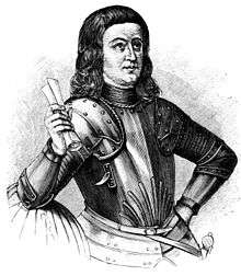 Martin Behaim. Engraving from Narrative and critical history of America, Volume 2 by Justin Winsor | |
| Born |
6 October 1459 Nuremberg |
| Died |
29 July 1507 Lisbon |
Martin Behaim (6 October 1459 – 29 July 1507), also known as Martin von Behaim and by various forms of Martin of Bohemia (Latin: Martinus Bohemus and de Boëmia; Portuguese: Martinho da Boémia; German: Martin Behaim von Schwarzbach) was a German mariner, artist, cosmographer, astronomer, philosopher, geographer, and explorer in service to King John II. His maps are sometimes held to have been influential on the Age of Discovery but he is now best known for his Erdapfel, the world's oldest surviving globe, which he produced for the Imperial City of Nuremberg.
Biography
Behaim was born in Nuremberg, according to one source, about 1436; other sources suggest as late as 1459; while others indicate that he was born in Bohemia to Martin Behaim and Agnes Schopper, the oldest of seven sons. Martin Behaim, the father, had many businesses including some in Venice, and later became an elected senator (1461), dying in 1474 (Agnes Schopper died on 8 July 1487). Their son received a scientific education, attending the highest schools where students were obligated to learn the languages of Europe and devote themselves to commercial pursuits and studies, before being sent to apprenticeships abroad.[1]
With a vocation in commerce, he parted around 1477 for Flanders, settling in Malines where he joined the business of Jorius van Dorpp, a vendor of clothing. They visited Frankfurt fairs in 1477, where van Dorpp sold his wares to a German merchant from Antwerp, and Behaim was motivated by his mother to return in the fall where he worked with Bartels von Eyb (a friend of the family). Writing to his uncle, Leonhard Behaim (18 September 1478), he expressed his desire not to return to Malines and wanted to improve his commercial skills. He eventually worked for another merchant, Fritz Heberlein (a native of Nuremberg but established in Antwerp) who allowed him to learn arithmetic and improve his skills. In 1480, trade between Portugal and Flanders attracted Behaim to Lisbon, and he became involved with the mercantile interests and overseas exploration that was occurring in the capital (from Flanders, Germany and the Hanseatic League). He was attracted to the knowledge of the navigators, cosmographers and explorers, acquiring a scientific reputation, and supposedly meeting with Christopher Columbus and Ferdinand Magellan and other celebrities then at the court of King John II of Portugal.
Between 1471-75, as a pupil (real or supposed) of the astronomer Regiomontanus (Johannes Müller von Königsberg of Königsberg in Franconia),[2] who died in 1476, he became linked to cosmography and cartography, resulting in an invitation from King John to a council on navigation in 1483, led by Abraham Zacuto. It is said that he introduced the cross-staff to Portugal (an invention first described by the French Jew Levi ben Gerson in the 14th century), but this is a matter of some controversy. Many navigational instruments had been in use for centuries by Scandinavian, Greek, Roman, Arab, and Chinese navigators, although there were subtle differences between them. He made improvements to the astrolabe by introducing brass instruments in place of cumbrous wooden ones. It also seems likely that he helped to prepare improved navigational tables of the Iberian Peninsula.
Behaim accompanied Diogo Cão during his second expedition (1485–86) along the coast of western Africa, reaching Cabo Negro and Cabo Ledo and returning by way of the Azores. It is still unclear whether Behaim sailed as far as reported, or whether he only reached the coast of Guinea, perhaps as far as the Bight of Benin. Perhaps these waypoints were only reached by the astronomers José Vizinho and João Afonso de Aveiro in 1484-86. Behaim's later history was less memorable: on his return to Lisbon from exploration in western Africa, he was knighted by King John, who afterwards employed him in various capacities.
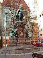
Following his marriage to D. Joana de Macedo in 1486, he resided on the Portuguese island of Faial in the Azores, where his father-in-law, Josse van Huerter, was Captain-donatário and leader of the Flemish community. In 1490, he returned to Nuremberg to handle the family business and design his famous globe, the Erdapfel. He returned to Faial in 1493 by way of Flanders and Lisbon, and he remained there until 1506. He died on 29 July 1507 while in Lisbon on business.
Before Magellan
During the Age of Exploration, it was common for the crown of Portugal to buy nautical charts from various sources, even if they were not accurate or showed unknown and mythic regions. Consequently, it is likely that during his familiarity with the Crown, that King John II would have purchased maps and charts from Martin Behaim, which might have depicted mysterious passages in an unknown land. This may account for the confusion caused by the story of Magellan's exploration of the southern route to the Pacific. Antonio Pigafetta, an Italian writer who accompanied Ferdinand Magellan notes that Magellan would have a partial drawing of the channel, analyzing it even before they had reached land.[3] A second chart, as Pigafetta alleges, would have been memorized by the explorer, in order to avoid others discovering the passage (particularly if his Spanish crew had mutinied). Although historians usually do not accept Behaim's influence on the discovery of the passage to the Pacific, it is fact that he is cited in the original Pigafetta's diary as the author of the original drawing of the channel. Magellan himself stated that he knew that a southern passage through a sound would lead to the "Southern Sea" (which Balboa had discovered in 1513 through the Isthmus of Panama), since he had seen the sound on a chart authored by Martin Behaim.[4] Pigafetta later wrote:
- But Hernando knew that it was the question of a very mysterious strait by which one could sail and which he had seen described on a map in the Treasury of the King of Portugal, the map having been made by an excellent man called Martin de Boemia.[5]
While Martin Behaim may be regarded as a contributor to the discovery of the Straits of Magellan, he might have only made a copy of an original sketch of the strait.[6]
The Erdapfel

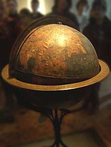
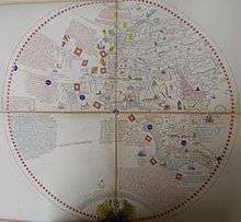
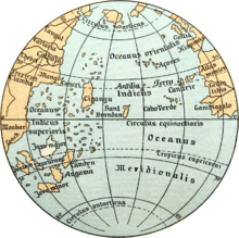
During his visit to his native home in Nuremberg, in collaboration with the painter Georg Glockendon, Martin Behaim constructed his familiar terrestrial globe between 1491 and 1493, one of two globes, which he called the Erdapfel (literally, the earth apple). It conforms to an idea of a globe envisioned in 1475 by Pope Sixtus IV, but has the added improvements of meridians and an equatorial line.
It is preserved in the German National Museum, on the same floor as Albrecht Dürer's gallery (owing to Nuremberg being the heart of the German Renaissance).
The influence of Ptolemy, who bequeathed the world latitude and longitude, is apparent, but every attempt is made to incorporate the discoveries of the later Middle Ages (including information from the voyages of Marco Polo, among others). Notwithstanding its fame, the Behaim Globe incorporates numerous errors that do not reflect contemporary geographical understanding. Western Africa is incorrect, though technology at the time made such calculations difficult; the Cape Verde archipelago lies hundreds of miles out of its proper place; and the Atlantic is filled with mythological islands that were psychologically important to isolated Medieval Christendom [7] Japan is located only 1,500 miles (2,400 km) off the coast, and was just where Marco Polo mentioned it, placing it temptingly within sailing distance of the Canaries. The Isle of St. Brendan is also located on this globe, but it contains the entire Western Hemisphere in capsule form. There are 16° errors in the location of many of the places, whereas modern maps seldom have more than 1°, because longitude was very difficult to ascertain before the invention of accurate clocks. The antiquity of this globe and the year of its execution, on the eve of the discovery of the Americas, makes it not just the oldest, but the most historically valuable globe. It corresponds particularly well with Columbus's notion of the Earth, and makes the notion of a jump across that little Ocean Sea to the Far East irresistible; he and Behaim drew their information from the same sources. Though less navigationally accurate than the beautiful Catalan portolani charts of the 14th century, as a scientific work it is of enormous importance; it may be the first terrestrial globe ever built, is tilted to spin at the correct angle, and represents an encyclopedia of the West's known world in the year 1492.
His family rescued the globe from city hall before it went the way of so many out-of-date artifacts. In 1992, it was moved to the Vienna University of Technology, to be studied at high resolution by the Behaim Digital Globe Project.[8] In 2011, a second digitalization by the German National Museum was begun.[9]
See also
Notes
- ↑ John Gottlieb Morris (1855), p.12
- ↑ John Gottlieb Morris (1855), p.15
- ↑ António Pigafetta (1524)
- ↑ Richard Hennig (1948), pp. 32-37.
- ↑ Giovanni Battista Ramusio (1554), p. 392.
- ↑ Johann Christoph Wagenseil (1682)
- ↑ Such as Antilia of the Seven Cities of the Christian Visigoth Kings, which would be used later in the naming of the Antilles.
- ↑ Lionel Dorffner: Der digitale Behaim-Globus - Visualisierung und Vermessung des historisch wertvollen Originals, in: Cartographica Helvetica 14/1996.
- ↑ Digitalisierung durch das Germanische Nationalmuseum Nürnberg (German)
References
- Pigafetta, Antonio (1524), Relazione del primo viaggio intorno al mondo (in Italian), retrieved 22 March 2011
- Hennig, Richard (1948), The Representation on Maps of the Magalhães Straits before Their Discovery, 5, Düsseldorf, Germany: Imago Mundi, pp. 32–37
- Ramusio, Giovanni Battista (1988) [1554], Navigazioni e viaggi (in Italian), 6, Torino, Italy: Einaudi, ISBN 88-06-59982-8
- Wagenseil, Johann Christoph (1682), Nuremberg, Germany (in German)
- Ozment, Steven (1990), Three Behaim Boys: Growing Up in Early Modern Germany. A Chronicle of Their Lives, New Haven, Connecticut: Yale University Press
- Morris, John Gottlieb (25 January 1855), Martin Behaim: The German Astronomer and Cosmographer of the Times of Columbus, Baltimore, Maryland: Maryland Historical Society/John Murphy & Co.
External links

- Martin Behaim's Erdapfel 1492 globe gores at the American Geographical Society Library Digital Collection
- Ernst G. Ravenstein (1908) Martin Behaim: his life and his globe - Linda Hall Library
- Martin Behaim's Erdapfel 1492 globe gores at Biblioteca Nacional de Portugal Digital Collection Biblioteca Nacional de Portugal