Maritime Silk Road
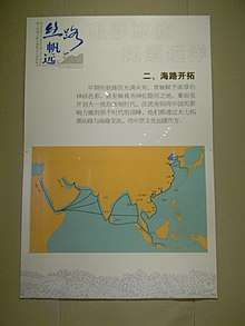
Maritime Silk Road or Maritime Silk Route refer to the maritime section of historic Silk Road that connects China to Southeast Asia, Indonesian archipelago, Indian subcontinent, Arabian peninsula, Somalia and all the way to Egypt and finally Europe, that flourished between 2nd-century BCE and 15th-century CE.[1]
The trade route encompassed numbers of seas and ocean; including South China Sea, Strait of Malacca, Indian Ocean, Gulf of Bengal, Arabian Sea, Persian Gulf and the Red Sea. The maritime route overlaps with historic Southeast Asian maritime trade, Spice trade, Indian Ocean trade and after 8th century—the Arabian naval trade network. The network also extend eastward to East China Sea and Yellow Sea to connect China with Korean Peninsula and Japanese archipelago.
On May 2017, experts from various fields have held a meeting in London to discuss the proposal to nominate "Maritime Silk Route" as a new UNESCO World Heritage Site.[2]
See also
- Maritime Silk Route Museum, Guangdong Province, China
- Ming treasure voyages led by Admiral Zheng He
- Belitung shipwreck