Maribor Lodge
| Mariborska koča | |
|---|---|
 | |
| Highest point | |
| Elevation | 1,142 m (3,747 ft) |
| Coordinates | 46°30′5.4″N 15°33′19.80″E / 46.501500°N 15.5555000°ECoordinates: 46°30′5.4″N 15°33′19.80″E / 46.501500°N 15.5555000°E |
| Geography | |
 Mariborska koča | |
| Parent range | Pohorje |
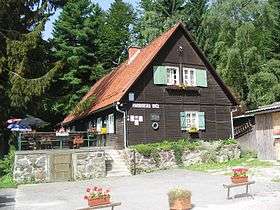
Mariborska koča (1142 m) is a mountain hut, which lies on small plain, on southern part of Pohorje under Reški vrh and Ledinek kogl. It was built in 1911 and was burnt by Germans during WW2.
Starting points
Neighbouring hills
- ½h : Mariborski razglednik (1147 m)
- ¾h : Bolfenk (1044 m)
- 1h : Ruška koča pri Arehu (1246m)
See also
References
- Slovenska planinska pot, Planinski vodnik, PZS, 2012, Milenko Arnejšek - Prle, Andraž Poljanec ISBN 978-961-6870-04-7
External links
This article is issued from
Wikipedia.
The text is licensed under Creative Commons - Attribution - Sharealike.
Additional terms may apply for the media files.