Marathos, Crete
| Marathos Μάραθος | |
|---|---|
 | |
 Marathos | |
| Coordinates: 35°22′N 25°0′E / 35.367°N 25.000°ECoordinates: 35°22′N 25°0′E / 35.367°N 25.000°E | |
| Country | Greece |
| Administrative region | Crete |
| Regional unit | Heraklion |
| Municipality | Malevizi |
| Municipal unit | Tylisos |
| City established | 1394 |
| Elevation | 400 m (1,300 ft) |
| Community[1] | |
| • Population | 351 (2011) |
| Time zone | UTC+2 (EET) |
| • Summer (DST) | UTC+3 (EEST) |
| Postal code | 71500 |
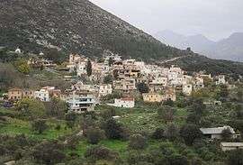
Marathos is a mountain village in the municipality of Malevizi, in the Crete region of Greece.[2] It is about 20 kilometres west of Heraklion. The Marathianos River runs nearby and flows down to Fodele.[3] The village relies mainly on agriculture, livestock and bee keeping.
On the main road there is a war monument commemorating the many battles on the island of Crete. It was built by the sculptor Yanni Klinakis.[4]
The village has 5 tavernas and a traditional cafeteria.
Doxa cavern
A short distance from the village is the historical cave of Doxa. At the entrance there is a map that shows the cave layout.[5]
Arkaliospilio cavern
At the foot of the mountain is Arkaliospilio cave.[6] A large part of this cave is still unexplored.
References
- ↑ "Απογραφή Πληθυσμού - Κατοικιών 2011. ΜΟΝΙΜΟΣ Πληθυσμός" (in Greek). Hellenic Statistical Authority.
- ↑ http://www.greece.com/destinations/Crete/Heraklion/Village/Marathos.html.
- ↑ http://www.interkriti.org/crete/iraklion/marathos_village.html
- ↑ http://www.tylisos.gr/index.php?option=content&task=view&id=135&lang=english
- ↑ http://www.originalcrete.com/en/article/marathos
- ↑ http://www.webcrete.net/index.php?option=com_content&view=article&id=1079:marathos&catid=71:traditional-villages-heraklionl-crete&directory=92
This article is issued from
Wikipedia.
The text is licensed under Creative Commons - Attribution - Sharealike.
Additional terms may apply for the media files.