Taipa-Mangonui
| Taipa-Mangonui | |
|---|---|
 Taipa-Mangonui | |
| Coordinates: 34°59′44″S 173°27′53″E / 34.99556°S 173.46472°E | |
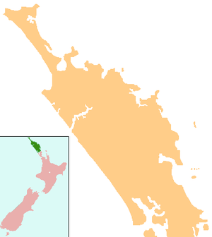
| Country | New Zealand |
| Region | Northland Region |
| District | Far North District |
| Population (June 2018)[1] | |
| • Total | 2,050 |
| Postcode(s) | 0420 |
Taipa-Mangonui or Taipa Bay-Mangonui refers to the string of small resort settlements Taipa, Cable Bay, Coopers Beach, and Mangonui which lie along the coast of Doubtless Bay - and are so close together that they have run together to form one larger settlement. The area had a combined population in 2013 of 1662.[2]
The "miniature conurbation" lies 150 kilometres by road northwest of Whangarei (though only 100 kilometres as the crow flies), and 20 kilometres northeast of Kaitaia. It is thus the northernmost centre in New Zealand with a population of above 1000, even though it is nearly 100 kilometres southeast of the northernmost tip of the North Island.
Earliest history
According to some Maori legends, the great Polynesian explorer and navigator, Kupe, sailed from Hawaiiki in his canoe, named Matahourua and landed at Taipa Bay. Others believe that he landed in the Hokianga Harbour around AD 900.
Centuries after Kupe’s landing his descendants, the chiefs Te Parata and Tu moana were said to have brought the ancestors of the Ngatikahu tribe to the Mangonui area around AD 1350, returning on the same canoe. Legend has it that they found insufficient fresh water at Otengi Bay and travelled up to the mouth of the Taipa River to land. There they settled and married into the local tribes.
Another canoe led by Moehuri is said to have been guided by a large shark into the Mangonui Harbour to a landing spot opposite the old post office. He made the shark Tapu and called the harbour Mangonui, meaning ‘Big Shark.’ in the Maori language.[3] In the 19th century, the spelling of Mongonui was more common,[4] and the Mongonui electorate filled one seat in Parliament between 1861 and 1881.[5]
Moehuri settled in Mangonui and married into the local people - remnants of the Ngati Awa and branch tribes of the Ngati Whatua. Pā were located all around the area, including one at Mill Bay, called Rangikapiti by Moehuri.
Taumarumaru pa was located on the headland between Mangonui and Coopers Beach while at the western end of Coopers Beach was Ohumuhumu pa, surrounded at one time by a large village.
Later history
In 1769 James Cook sailed past and noted that it was "doubtless a bay...", hence the modern name of Doubtless Bay. Eight days later the first Europeans to land were Jean De Surville and his crew aboard St Jean Baptiste. They landed at what he named Lauriston Bay to get fresh vegetables to combat scurvy. Around twenty years later, whalers and sealers from all over the western world arrived, and called the area Coopers Beach - thought to have come from the coopers on the whaleships.
The first European settler is considered to be James David Berghan from Ireland who arrived in Mangonui in 1831. By the later half of the 19th century, flax and timber industries were flourishing in the area. Other setters developed farms and businesses in the area while some married into the native population. The dynamic mix of settlers coming from various parts of Europe, combined with the Maori population provided Mangonui with a rich heritage.
When Hone Heke destroyed Kororareka (Russell), the evacuation saw 40 to 50 ships in the Mangonui Harbour. The town assumed new importance and was considered the country’s second capital. The last whaling ship visited Mangonui in 1885.
Education
Taipa Area School is a composite (years 1-15) school with a roll of 464.[6] The school claims to be the only one in New Zealand to have a team of students who are qualified surf lifeguards patrolling beach activities during terms 1 and 4.[7]
Mangonui School is a contributing primary (years 1-6) school with a roll of 151.[8] The school opened in 1857, and one of the original buildings is still in use as the school library.[9]
Both schools are coeducational and have a decile rating of 3. Coordinates: 34°59′44″S 173°27′53″E / 34.99556°S 173.46472°E
Gallery
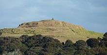 Rangikapiti Pa as seen from George Street Mangonui
 Rangikapiti Pa and Inlet to the Mangonui harbour
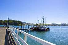 The harbour at Mangonui
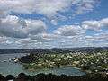 Dense housing around Mangonui
 Coopers Beach from Rangikapiti
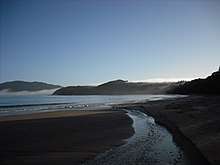 Coopers Beach
Notes
- ↑ "Subnational Population Estimates: At 30 June 2018 (provisional)". Statistics New Zealand. 23 October 2018. Retrieved 23 October 2018. For urban areas, "Subnational population estimates (UA, AU), by age and sex, at 30 June 1996, 2001, 2006-18 (2018 boundary)". Statistics New Zealand. 23 October 2018. Retrieved 23 October 2018.
- ↑ http://archive.stats.govt.nz/Census/2013-census/profile-and-summary-reports/quickstats-about-a-place.aspx?request_value=13072&parent_id=13069&tabname=
- ↑ "This Is The Place - Story Details The Naming of Mangonui". thisistheplace.org.nz. Retrieved 2010-07-19.
- ↑ Cyclopedia Company Limited (1902). "Mongonui". The Cyclopedia of New Zealand : Auckland Provincial District. Christchurch: The Cyclopedia of New Zealand. Retrieved 11 February 2013.
- ↑ Wilson, James Oakley (1985) [First ed. published 1913]. New Zealand parliamentary record, 1840–1984 (4 ed.). Wellington: V.R. Ward, Govt. Printer. p. 267. OCLC 154283103.
- ↑ "Te Kete Ipurangi - Taipa Area School". Ministry of Education.
- ↑ "Welcome to Taipa Area School".
- ↑ "Te Kete Ipurangi - Mangonui School". Ministry of Education.
- ↑ "All About Mangonui School".
External links
| Wikimedia Commons has media related to |