Rio Negro Bridge
Coordinates: 3°7′19″S 60°04′46″W / 3.12194°S 60.07944°W
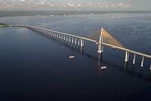
| Rio Negro Bridge | |
|---|---|
 | |
| Coordinates | 3°7′19″S 60°04′46″W / 3.12194°S 60.07944°W |
| Carries | 4 lanes of roadway |
| Crosses | Rio Negro |
| Locale | Manaus and Iranduba, Brazil |
| Official name | Journalist Phelippe Daou Bridge |
| Characteristics | |
| Design | Cable-stayed bridge |
| Total length | 3.6 km (2,23 miles) |
| Height | 158 metres (518 ft)[1] |
| Longest span | 2x200 metres (660 ft) |
| Clearance above | 55 metres (180 ft)[1] |
| History | |
| Construction start | November, 2007 |
| Opened | October 24, 2011 |
| Statistics | |
| Daily traffic | 4 (2 in each direction) |
The Journalist Phelippe Daou Bridge or Rio Negro Bridge (Portuguese: Ponte Rio Negro) is a cable-stayed bridge over the Rio Negro with 3,595 metres (11,795 ft) of length that links the cities of Manaus and Iranduba in Brazil.[2]
 Bridge in sunset
 Inauguration of the bridge
 Rio Negro Bridge
References
External links
This article is issued from
Wikipedia.
The text is licensed under Creative Commons - Attribution - Sharealike.
Additional terms may apply for the media files.