Malnesberget
| Malnesberget | |
|---|---|
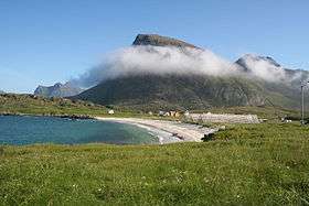 Malnesberget seen from Hovden | |
| Highest point | |
| Elevation | 529 m (1,736 ft) [1] |
| Coordinates | 68°47′57″N 14°33′59″E / 68.79917°N 14.56639°ECoordinates: 68°47′57″N 14°33′59″E / 68.79917°N 14.56639°E |
| Geography | |
| Climbing | |
| Easiest route | From below Tussen near Malnes |


Malnesberget (English: Mount Malnes) is a hill (elevation 529 meters or 1,736 feet)[1] in the municipality of Bø in Nordland county, Norway.
It rises south of Malnes.[2] It can be climbed from Malnes starting about 500 meters (1,600 ft) north of Tussen (elevation 198 meters or 650 feet), a smaller hill directly above Norwegian County Road 915.
References
- 1 2 Malnesberget Statens kartverk: Norgeskart.no.
- ↑ "Malnesberget, Bø (Nordland)" (in Norwegian). yr.no. Retrieved February 6, 2017.
This article is issued from
Wikipedia.
The text is licensed under Creative Commons - Attribution - Sharealike.
Additional terms may apply for the media files.