Magma Geopark
Coordinates: 58°26′52″N 6°0′22″E / 58.44778°N 6.00611°E Magma Geopark is the second Geopark to be designated in Norway, having gained membership of both the European Geoparks Network and Global Network of National Geoparks in 2010. In November 2016 UNESCO established the new International Geoscience and Geoparks Programme and the UNESCO Global Geopark are part of it. Magma Geopark is an area of 2329 km² based on the largest layered intrusion and anorthosite area found in Europe and it is situated in southwest of Norway in the municipalities of Bjerkreim, Eigersund, Flekkefjord, Lund and Sokndal.
1,500 million years ago, the region had a landscape of red-hot magma and high mountains. Through millions of years, glaciers helped to form the landscape we see in the area today. The main rock type is anorthosite, which is more common on the Moon than on the surface of Earth.
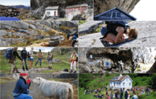
Magma Geopark has several nature, culture, history and industrial attractions for both local visitors or tourists. The area has wide network routes and locations for outdoor activities, such as hiking, biking, climbing, kayaking.
The geoVR virtual exhibition is now ready for the public in the centre of Egersund.
From 1 June at the office located in Elvegaten 23 you can also book your bike and explore the landscape alone or with expert guides.
From Stavanger you can easily reach the Geopark head quarter by train, which run every hour.
Now is possible to book tours at: magmageopark.no