Magaruque Island
.jpg) Dhow and fishermen on Magaruque Island, August 2006 | |
| Geography | |
|---|---|
| Coordinates | 21°57′59″S 35°25′49″E / 21.96639°S 35.43028°ECoordinates: 21°57′59″S 35°25′49″E / 21.96639°S 35.43028°E |
| Archipelago | Bazaruto Archipelago |
| Area | 2 km2 (0.77 sq mi) |
| Administration | |
|
Mozambique | |
Magaruque Island, formerly Ilha Santa Isabel, is part of the Bazaruto Archipelago, off the coast of Mozambique. It is located 5.6 km south of Benguerra Island, and 9.9 km east of Ponta Chuè on the mainland of Mozambique.
The island is 2.4 km long north-south, and up to 1.0 km wide. Its area is less than 2 km².
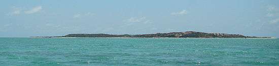
A western view of the island
This article is issued from
Wikipedia.
The text is licensed under Creative Commons - Attribution - Sharealike.
Additional terms may apply for the media files.