Mandécali
| Mandécali | |
|---|---|
| Arrondissement and town | |
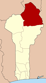
 Mandécali Location in Benin | |
| Coordinates: 11°42′26″N 03°32′54″E / 11.70722°N 3.54833°ECoordinates: 11°42′26″N 03°32′54″E / 11.70722°N 3.54833°E | |
| Country |
|
| Department | Alibori Department |
| Commune | Malanville |
| Time zone | UTC+1 (WAT) |
Mandécali or Mandékali or Madékali is a town and arrondissement in the Alibori Department of northeastern Benin. It is an administrative division under the jurisdiction of the commune of Malanville. According to the population census conducted by the Institut National de la Statistique Benin on February 15, 2002, the arrondissement had a total population of 14,105.[1]
References
- ↑ Institut National de la Statistique Benin, accessed by Geohive Archived 2009-10-15 at the Wayback Machine., accessed January 16, 2010
This article is issued from
Wikipedia.
The text is licensed under Creative Commons - Attribution - Sharealike.
Additional terms may apply for the media files.